Skip to search
Skip to main content
Digital Commonwealth
Sign Up / Log In
Search for
Search
Search
Search
Basic
Advanced
Explore
Map
Collections
Institutions
Formats
For Educators
Primary Source Sets
Lesson Plans
Using Primary Sources
Searching Digital Commonwealth
For Institutions
Join Digital Commonwealth
Conferences, Trainings, & Events
How to Contribute Collections
Digitization Services
Board & Committees
Frequently Asked Questions
About
About Digital Commonwealth
News & Announcements
Copyright & Terms of Use
Harmful Content Statement
Partners
API
Contact Us
Boston Public Library
Norman B. Leventhal Map Center Collection
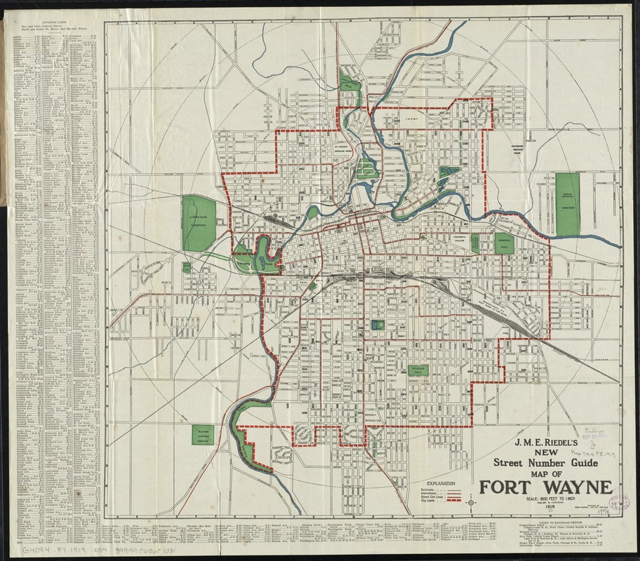
J.M.E. Riedel's new street number guide map of Fort Wayne
J.M.E. Riedels new street number guide map of Fort Wayne
×
Item Information
Title:
J.M.E. Riedel's new street number guide map of Fort Wayne
Title (alt.):
New street number guide map of Fort Wayne
J.M.E. Riedel's Pocket map of Fort Wayne, Indiana
Pocket map of Fort Wayne, Indiana
Description:
Shows radial distances, railroad, interurban and streetcar lines.
Creator:
Riedel, J. M. E
Date:
[ca. 1919]
Format:
Maps/Atlases
Location:
Boston Public Library
Norman B. Leventhal Map Center
Collection (local):
Norman B. Leventhal Map Center Collection
Subjects:
Railroads--Indiana--Fort Wayne--Maps
Street-railroads--Indiana--Fort Wayne--Maps
Fort Wayne (Ind.)--Maps
Places:
Allen (county)
>
Fort Wayne
Extent:
1 map : col. ; 48 x 50 cm., on sheet 54 x 61 cm., folded in cover 19 x 11 cm.
Permalink:
https://ark.digitalcommonwealth.org/ark:/50959/1257b828q
Terms of Use:
No known copyright restrictions.
No known restrictions on use.
Publisher:
[Fort Wayne, Ind.] : J.M.E. Riedel
Scale:
Scale [1:19,200]. 1600 ft. to 1 inch
Language:
English
Notes:
Approved by Frank M. Randall, city civil engineer.
Indexed.
Identifier:
06_01_011159
Call #:
G4094.F7 1919 .R54
Barcode:
39999065681031
show more...
View MODS XML
More Like This
The 100th anniversary map of Abraham Lincoln's visit to ...
1630 shoreline
1879. Progress map of the U.S. Geographical Surveys west of the ...
1903 Map of Salem and surrounding places
Find More Like This >>
Tools
Share
Facebook
Pinterest
X
Reddit
Tumblr
Email
Copy link
Add to Folder
Questions/Comments
Cite This Item
IIIF Manifest
Downloads
Primary (full resolution, uncompressed)
(TIF, 151 MB)
Large (full resolution)
(JPEG, 12.7 MB)
Medium
(JPEG, 317 KB)