Skip to search
Skip to main content
Digital Commonwealth
Sign Up / Log In
Search for
Search
Search
Search
Basic
Advanced
Explore
Map
Collections
Institutions
Formats
For Educators
Primary Source Sets
Lesson Plans
Using Primary Sources
Searching Digital Commonwealth
For Institutions
Join Digital Commonwealth
Conferences, Trainings, & Events
How to Contribute Collections
Digitization Services
Board & Committees
Frequently Asked Questions
About
About Digital Commonwealth
News & Announcements
Copyright & Terms of Use
Harmful Content Statement
Partners
API
Contact Us
Boston Public Library
Norman B. Leventhal Map Center Collection
Pennsylvania
Pennsylvania
×
Item Information
Title:
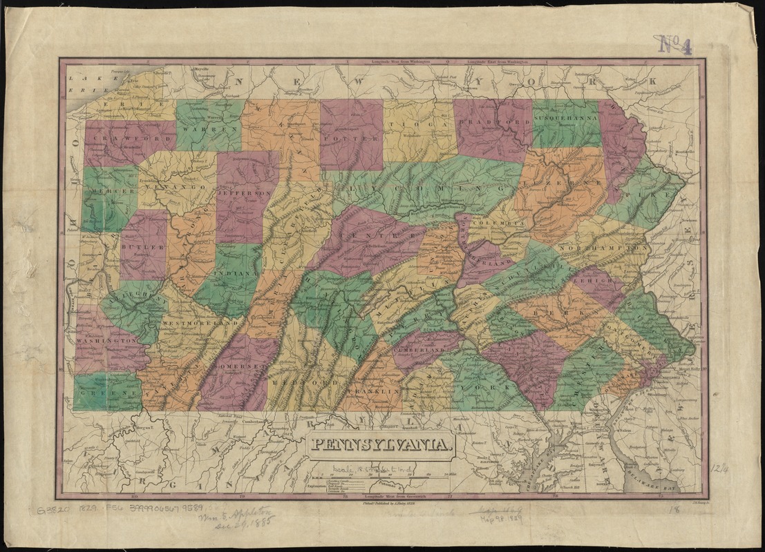
Pennsylvania
Description:
Shows roads, canals, railroads, and proposed railroads. Counties are distinguished by color. Earliest general map of the state to show railroads.
Creator:
Finley, A. (Anthony)
Name on Item:
J.H. Young sc.
Date:
1829
Format:
Maps/Atlases
Location:
Boston Public Library
Norman B. Leventhal Map Center
Collection (local):
Norman B. Leventhal Map Center Collection
Subjects:
Pennsylvania--Maps
Places:
Pennsylvania
Extent:
1 map : hand col. ; 32 x 47 cm.
Permalink:
https://ark.digitalcommonwealth.org/ark:/50959/4m90f4809
Terms of Use:
No known copyright restrictions.
No known restrictions on use.
Publisher:
Philada : A. Finley
Scale:
Scale [ca. 1:1,130,000]
Language:
English
Notes:
Relief shown pictorially.
Prime meridians: Washington and Greenwich.
Identifier:
06_01_010916
Call #:
G3820 1829 .F56
Barcode:
39999065679589
LCCN:
98688548
show more...
View MODS XML
More Like This
Clemens' map of Pennsylvania
Geological and topographical map of the anthracite fields of ...
Geological map of south-west Pennsylvania, with special reference ...
Grundriss von Philadelphia der hauptstadt in Pensylvanien und ...
Find More Like This >>
Tools
Share
Facebook
Pinterest
X
Reddit
Tumblr
Email
Copy link
Add to Folder
Questions/Comments
Cite This Item
IIIF Manifest
Downloads
Primary (full resolution, uncompressed)
(TIF, 93.2 MB)
Large (full resolution)
(JPEG, 7.83 MB)
Medium
(JPEG, 353 KB)
GeoTIFF (georeferenced)
(TIF, 115 MB)