Skip to search
Skip to main content
Digital Commonwealth
Sign Up / Log In
Search for
Search
Search
Search
Basic
Advanced
Explore
Map
Collections
Institutions
Formats
For Educators
Primary Source Sets
Lesson Plans
Using Primary Sources
Searching Digital Commonwealth
For Institutions
Join Digital Commonwealth
Conferences, Trainings, & Events
How to Contribute Collections
Digitization Services
Board & Committees
Frequently Asked Questions
About
About Digital Commonwealth
News & Announcements
Copyright & Terms of Use
Harmful Content Statement
Partners
API
Contact Us
Boston Public Library
Norman B. Leventhal Map Center Collection
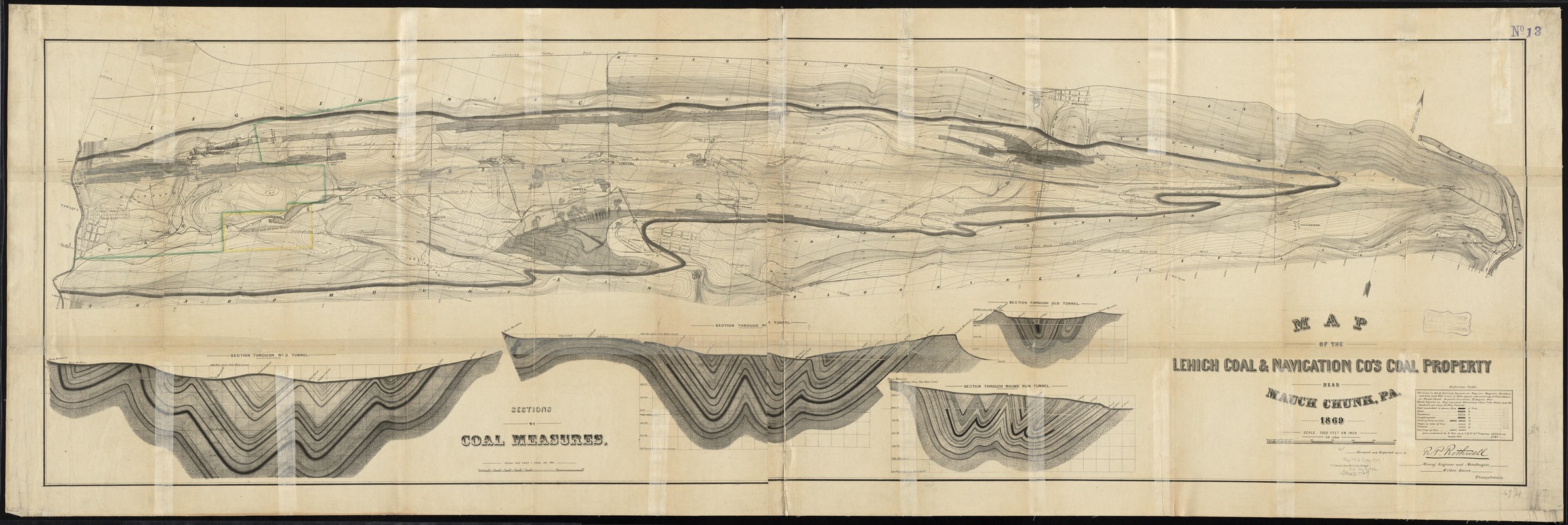
Map of the Lehigh Coal & Navigation Co.'s coal property near Mauch Chunk, Pa
Map of the Lehigh Coal & Navigation Co.s coal property near Mauch Chunk, Pa
×
Item Information
Title:
Map of the Lehigh Coal & Navigation Co.'s coal property near Mauch Chunk, Pa
Creator:
Rothwell, Richard P. (Richard Pennefather), 1836-1901
Name on Item:
surveyed and reported upon by R.P. Rothwell, mining engineer and metallurgist, Wilkes-Barre, Pennsylvania.
Date:
1869
Format:
Maps/Atlases
Location:
Boston Public Library
Norman B. Leventhal Map Center
Collection (local):
Norman B. Leventhal Map Center Collection
Subjects:
Lehigh Coal and Navigation Company
Coal mines and mining--Pennsylvania--Carbon County--Maps
Mines and mineral resources--Pennsylvania--Carbon County--Maps
Carbon County (Pa.)--Maps
Mauch Chunk (Pa.)--Maps
Places:
Carbon (county)
>
Jim Thorpe
Extent:
1 map ; 54 x 181 cm.
Permalink:
https://ark.digitalcommonwealth.org/ark:/50959/4m90f500k
Terms of Use:
No known copyright restrictions.
No known restrictions on use.
Publisher:
Philadelphia [Pa.] : P.S. Duval, Son & Co.
Scale:
Scale 1:12,000. 1000 feet an inch
Language:
English
Notes:
Relief shown by contours.
Oriented with north towards the upper right.
Insets: Four sections of coal measures -- Scale 1:4800 (400 feet one inch).
Identifier:
06_01_010932
Call #:
G3823.C36H9 1869 .R68
Barcode:
39999065679381
show more...
View MODS XML
More Like This
Map of the counties of Monroe and Carbon, Pennsylvania
Letter from Benjamin Smith Lyman to William D. Kelly
The 100th anniversary map of Abraham Lincoln's visit to ...
1630 shoreline
Find More Like This >>
Tools
Share
Facebook
Pinterest
X
Reddit
Tumblr
Email
Copy link
Add to Folder
Questions/Comments
Cite This Item
IIIF Manifest
Downloads
Primary (full resolution, uncompressed)
(TIF, 500 MB)
Large (full resolution)
(JPEG, 42 MB)
Medium
(JPEG, 575 KB)