Skip to search
Skip to main content
Digital Commonwealth
Sign Up / Log In
Search for
Search
Search
Search
Basic
Advanced
Explore
Map
Collections
Institutions
Formats
For Educators
Primary Source Sets
Lesson Plans
Using Primary Sources
Searching Digital Commonwealth
For Institutions
Join Digital Commonwealth
Conferences, Trainings, & Events
How to Contribute Collections
Digitization Services
Board & Committees
Frequently Asked Questions
About
About Digital Commonwealth
News & Announcements
Copyright & Terms of Use
Harmful Content Statement
Partners
API
Contact Us
Boston Public Library
Norman B. Leventhal Map Center Collection
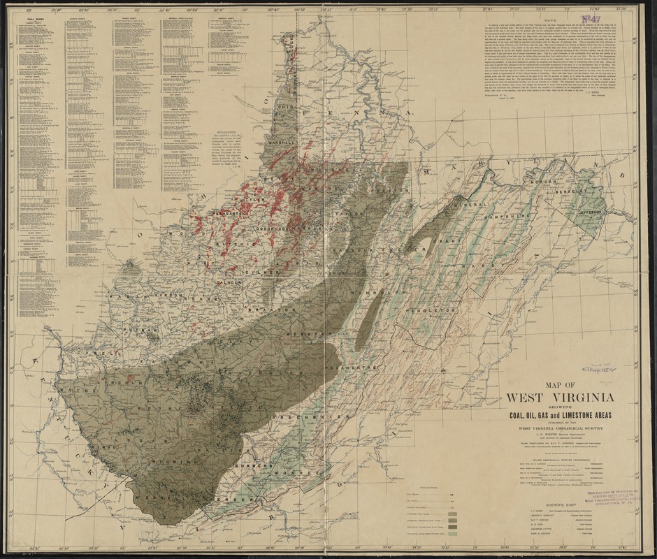
Map of West Virginia showing coal, oil, gas and limestone areas
Map of West Virginia showing coal, oil, gas and limestone areas
×
Item Information
Title:
Map of West Virginia showing coal, oil, gas and limestone areas
Creator:
West Virginia Geological and Economic Survey
Name on Item:
published by the West Virginia Geological Survey, I.C. White, state geologist and author of geologic features; base prepared by Ray V. Hennen, assistant geologist, from the topographic sheets of the U.S. Geological Survey.
Date:
1908
Format:
Maps/Atlases
Location:
Boston Public Library
Norman B. Leventhal Map Center
Collection (local):
Norman B. Leventhal Map Center Collection
Subjects:
Coalfields--West Virginia--Maps
Coal mines and mining--West Virginia--Maps
Oil fields--West Virginia--Maps
Gas fields--West Virginia--Maps
Limestone mines and mining--West Virginia--Maps
West Virginia--Maps
Places:
West Virginia
Extent:
1 map : col. ; 93 x 108 cm.
Permalink:
https://ark.digitalcommonwealth.org/ark:/50959/4m90f606f
Terms of Use:
No known copyright restrictions.
No known restrictions on use.
Publisher:
Morgantown, W. Va : West Virginia Geological Survey
Scale:
Scale [1:443,520]. 7 mi. to the inch.
Language:
English
Notes:
Relief shown by contours and spot heights.
Includes text and key to companies owning coal mines.
Identifier:
06_01_011018
Call #:
G3891.H5 1908 .W47
Barcode:
39999065680421
LCCN:
gs 08000325
show more...
View MODS XML
More Like This
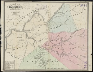
Colton's map of the oil district of West Virginia and Ohio
Map of the oil district of West Virginia
Map of the Virginian Railway
State of West Virginia and part of Maryland : coal fields and ...
Find More Like This >>
Tools
Share
Facebook
Pinterest
X
Reddit
Tumblr
Email
Copy link
Add to Folder
Questions/Comments
Cite This Item
IIIF Manifest
Downloads
Primary (full resolution, uncompressed)
(TIF, 374 MB)
Large (full resolution)
(JPEG, 31.4 MB)
Medium
(JPEG, 312 KB)
GeoTIFF (georeferenced)
(TIF, 453 MB)