Skip to search
Skip to main content
Digital Commonwealth
Sign Up / Log In
Search for
Search
Search
Search
Basic
Advanced
Explore
Map
Collections
Institutions
Formats
For Educators
Primary Source Sets
Lesson Plans
Using Primary Sources
Searching Digital Commonwealth
For Institutions
Join Digital Commonwealth
Conferences, Trainings, & Events
How to Contribute Collections
Digitization Services
Board & Committees
Frequently Asked Questions
About
About Digital Commonwealth
News & Announcements
Copyright & Terms of Use
Harmful Content Statement
Partners
API
Contact Us
Boston Public Library
Norman B. Leventhal Map Center Collection
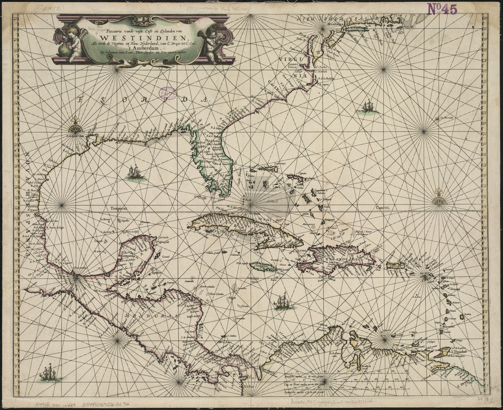
Pascaarte vande vaste cust en eylanden van Westindien, als mede de Virginis en Nieu-Nederland, van C. Droge tot C. Cod
Pascaarte vande vaste cust en eylanden van Westindien, als mede de Virginis en Nieu-Nederland, van C. Droge tot C. Cod
×
Item Information
Title:
Pascaarte vande vaste cust en eylanden van Westindien, als mede de Virginis en Nieu-Nederland, van C. Droge tot C. Cod
Creator:
Loon, J. van, ca. 1611-1686
Name on Item:
by Iohannes van Loon.
Date:
[1661]
Format:
Maps/Atlases
Location:
Boston Public Library
Norman B. Leventhal Map Center
Collection (local):
Norman B. Leventhal Map Center Collection
Subjects:
West Indies--Maps--Early works to 1800
Caribbean Area--Maps--Early works to 1800
Places:
West Indies
Caribbean Sea
Extent:
1 map : col. ; 43 x 52 cm.
Permalink:
https://ark.digitalcommonwealth.org/ark:/50959/6t053r66q
Terms of Use:
No known copyright restrictions.
No known restrictions on use.
Publisher:
Amsterdam : Iohannes van Loon
Scale:
Scale ca. 1:2,705,000.
Language:
Dutch
Notes:
Shows the Caribbean area, with the Atlantic coast north to Cape Cod, Central America, and South America.
Cataloging, conservation, and digitization made possible in part by The National Endowment for the Humanities: Exploring the human endeavor.
Notes (date):
This date is inferred.
Identifier:
06_01_006420
Call #:
G4900 1661 .L66x
Barcode:
39999059025492
show more...
View MODS XML
More Like This
Carte des isles Antilles et du Golfe du Mexique : avec la majeure ...
Carte du Golphe du Mexique et des isles Antilles : reduite de la ...
Culiacanae, Americae regionis, descriptio : Hispaniolae, Cubae, ...
Grand theatre de la guerre en Amerique suivant les plus nouvelles ...
Find More Like This >>
Tools
Share
Facebook
Pinterest
X
Reddit
Tumblr
Email
Copy link
Add to Folder
Questions/Comments
Cite This Item
IIIF Manifest
Downloads
Primary (full resolution, uncompressed)
(TIF, 174 MB)
Large (full resolution)
(JPEG, 14.6 MB)
Medium
(JPEG, 408 KB)