Skip to search
Skip to main content
Digital Commonwealth
Sign Up / Log In
Search for
Search
Search
Search
Basic
Advanced
Explore
Map
Collections
Institutions
Formats
For Educators
Primary Source Sets
Lesson Plans
Using Primary Sources
Searching Digital Commonwealth
For Institutions
Join Digital Commonwealth
Conferences, Trainings, & Events
How to Contribute Collections
Digitization Services
Board & Committees
Frequently Asked Questions
About
About Digital Commonwealth
News & Announcements
Copyright & Terms of Use
Harmful Content Statement
Partners
API
Contact Us
Boston Public Library
Norman B. Leventhal Map Center Collection
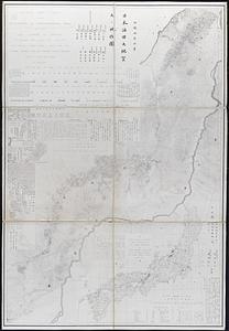
[Map of Japan]
[Map of Japan]
×
Item Information
Title:
[Map of Japan]
Creator:
Tsurumine, Shigenobu, 1788-1859
Date:
[ca. 1844]
Format:
Maps/Atlases
Location:
Boston Public Library
Norman B. Leventhal Map Center
Collection (local):
Norman B. Leventhal Map Center Collection
Subjects:
Japan--Maps
Places:
Japan
Extent:
1 map : col. ; 18 x 21 cm.
Permalink:
https://ark.digitalcommonwealth.org/ark:/50959/794083211
Terms of Use:
No known copyright restrictions.
No known restrictions on use.
Publisher:
S.l : s.n.
Scale:
Scale not given.
Language:
Japanese
Notes:
Title provided by cataloger.
Map of Japan, in Japanese.
Wood block print.
Identifier:
06_01_006600
Call #:
G7960 1844 .T78x
Barcode:
39999059027001
show more...
View MODS XML
More Like This
Chart of the coast of China and of the Japan islands : including ...
Geological and topographical maps of oil lands of Japan
Insularum Japonicarum : tabulae geographicae secundum opus = ...
Japan and its relation to the territory bordering on the Pacific Ocean
Find More Like This >>
Tools
Share
Facebook
Pinterest
X
Reddit
Tumblr
Email
Copy link
Add to Folder
Questions/Comments
Cite This Item
IIIF Manifest
Downloads
Primary (full resolution, uncompressed)
(TIF, 64.2 MB)
Large (full resolution)
(JPEG, 5.39 MB)
Medium
(JPEG, 329 KB)
![[Map of Japan]](https://bpldcassets.blob.core.windows.net/derivatives/images/commonwealth:794083229/image_access_800.jpg)