Skip to search
Skip to main content
Digital Commonwealth
Sign Up / Log In
Search for
Search
Search
Search
Basic
Advanced
Explore
Map
Collections
Institutions
Formats
For Educators
Primary Source Sets
Lesson Plans
Using Primary Sources
Searching Digital Commonwealth
For Institutions
Join Digital Commonwealth
Conferences, Trainings, & Events
How to Contribute Collections
Digitization Services
Board & Committees
Frequently Asked Questions
About
About Digital Commonwealth
News & Announcements
Copyright & Terms of Use
Harmful Content Statement
Partners
API
Contact Us
Boston Public Library
Norman B. Leventhal Map Center Collection
/
American Revolutionary War-Era Maps (Collection of Distinction)
/
Maritime Charts and Atlases (Collection of Distinction)
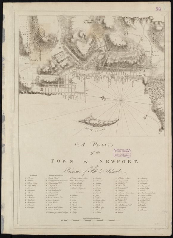
A plan of the town of Newport in the province of Rhode Island
A plan of the town of Newport in the province of Rhode Island
×
Item Information
Title:
A plan of the town of Newport in the province of Rhode Island
Creator:
Des Barres, Joseph F. W. (Joseph Frederick Wallet), 1722-1824
Date:
1776
Format:
Maps/Atlases
Location:
Boston Public Library
Norman B. Leventhal Map Center
Collection (local):
Norman B. Leventhal Map Center Collection
Subjects:
Nautical charts--Rhode Island--Newport--Early works to 1800
Newport (R.I.)--Maps--Early works to 1800
Places:
Rhode Island
>
Newport (county)
>
Newport
Extent:
1 chart ; 41 x 49 cm, on sheet 71 x 51 cm.
Permalink:
https://ark.digitalcommonwealth.org/ark:/50959/7h149x16z
Terms of Use:
No known copyright restrictions.
No known restrictions on use.
Publisher:
[London] : J F W Des Barres
Edition:
2nd state.
Scale:
Scale [ca. 1:6,250]
Language:
English
Notes:
Relief shown by hachures ans shading.
Includes indexes to wharfs, public buildings, and streets.
Appears in the author's Atlantic Neptune. London : J.F.W. Des Barres, 1777-[1781].
Identifier:
06_01_004988
Call #:
G1106.P5 D47 1777
Barcode:
30000003811378
show more...
View MODS XML
More Like This
A plan of the town of Newport in the province of Rhode Island
The 100th anniversary map of Abraham Lincoln's visit to ...
1630 shoreline
1879. Progress map of the U.S. Geographical Surveys west of the ...
Find More Like This >>
Tools
Share
Facebook
Pinterest
X
Reddit
Tumblr
Email
Copy link
Add to Folder
Questions/Comments
Cite This Item
IIIF Manifest
Downloads
Primary (full resolution, uncompressed)
(TIF, 107 MB)
Large (full resolution)
(JPEG, 8.96 MB)
Medium
(JPEG, 151 KB)