Skip to search
Skip to main content
Digital Commonwealth
Sign Up / Log In
Search for
Search
Search
Search
Basic
Advanced
Explore
Map
Collections
Institutions
Formats
For Educators
Primary Source Sets
Lesson Plans
Using Primary Sources
Searching Digital Commonwealth
For Institutions
Join Digital Commonwealth
Conferences, Trainings, & Events
How to Contribute Collections
Digitization Services
Board & Committees
Frequently Asked Questions
About
About Digital Commonwealth
News & Announcements
Copyright & Terms of Use
Harmful Content Statement
Partners
API
Contact Us
Boston Public Library
Norman B. Leventhal Map Center Collection
/
Urban Maps (Collection of Distinction)
/
Boston and New England Maps (Collection of Distinction)
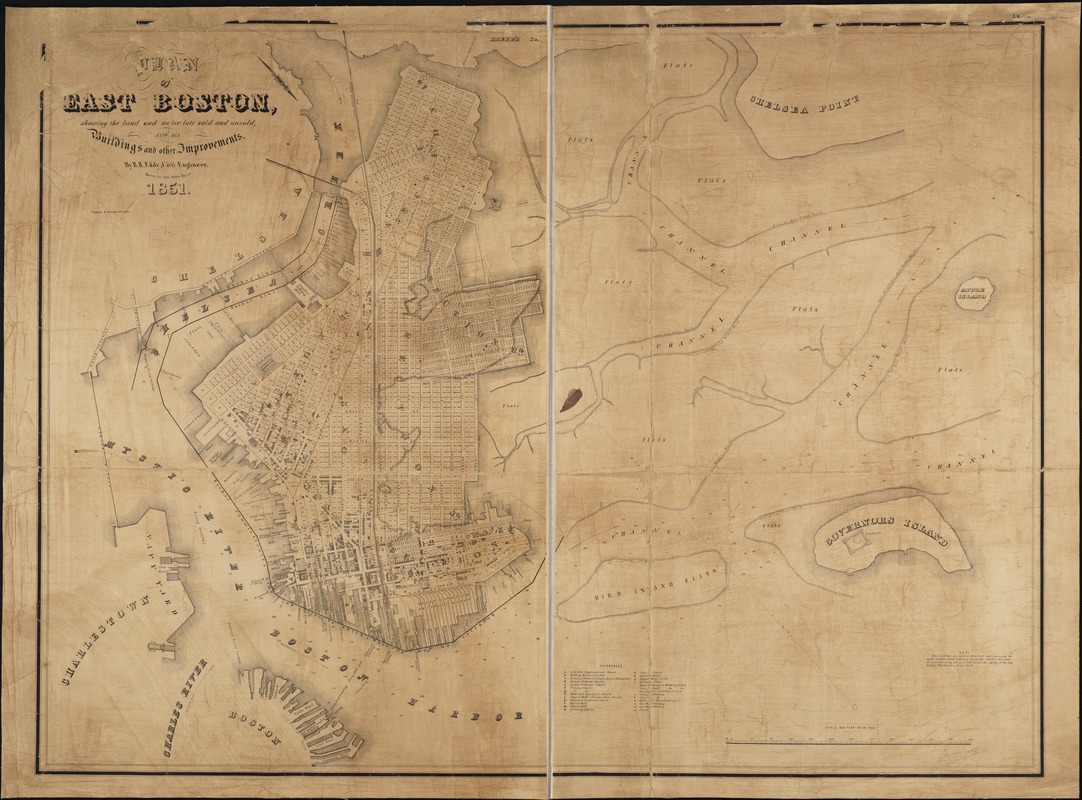
Plan of East Boston showing the land and water lots sold and unsold, also all buildings and other improvements
Plan of East Boston showing the land and water lots sold and unsold, also all buildings and other improvements
×
Item Information
Title:
Plan of East Boston showing the land and water lots sold and unsold, also all buildings and other improvements
Creator:
Eddy, R. H. (Robert Henry), 1812-1887
Name on Item:
by R.H. Eddy ; drawn by John Noble.
Date:
1851
Format:
Maps/Atlases
Location:
Boston Public Library
Norman B. Leventhal Map Center
Collection (local):
Norman B. Leventhal Map Center Collection
Subjects:
Real property--Massachusetts--Boston--Maps
Land tenure--Massachusetts--Boston--Maps
East Boston (Boston, Mass.)--Maps
East Boston (Boston, Mass.)
Places:
Suffolk (county)
>
Boston
>
East Boston
Extent:
1 map ; 93 x 123 cm.
Permalink:
https://ark.digitalcommonwealth.org/ark:/50959/9s161f43g
Terms of Use:
No known copyright restrictions.
No known restrictions on use.
Publisher:
[Boston, Mass.] : Tappan & Bradford's Lith.
Scale:
Scale 1:4,800.
Language:
English
Notes:
Oriented with north toward the lower right.
Depths shown by hachures.
Includes index to points of interest.
Identifier:
06_01_003887
Call #:
G3764.B6:2E2G46 1851 .E3
Barcode:
39999059002533
show more...
View MODS XML
More Like This
Plan of East Boston : shewing the location of a mill dam and other ...
Plan of sections of 1, 2 & 3, East Boston
Hyde Park & Fairmount : in Dorchester & Milton, Norfolk Co
Map of Dorchester Mass
Find More Like This >>
Tools
Share
Facebook
Pinterest
X
Reddit
Tumblr
Email
Copy link
Add to Folder
Questions/Comments
Cite This Item
IIIF Manifest
Downloads
Primary (full resolution, uncompressed)
(TIF, 359 MB)
Large (full resolution)
(JPEG, 30.1 MB)
Medium
(JPEG, 277 KB)
GeoTIFF (georeferenced)
(TIF, 645 MB)