Skip to search
Skip to main content
Digital Commonwealth
Sign Up / Log In
Search for
Search
Search
Search
Basic
Advanced
Explore
Map
Collections
Institutions
Formats
For Educators
Primary Source Sets
Lesson Plans
Using Primary Sources
Searching Digital Commonwealth
For Institutions
Join Digital Commonwealth
Conferences, Trainings, & Events
How to Contribute Collections
Digitization Services
Board & Committees
Frequently Asked Questions
About
About Digital Commonwealth
News & Announcements
Copyright & Terms of Use
Harmful Content Statement
Partners
API
Contact Us
Boston Public Library
Norman B. Leventhal Map Center Collection
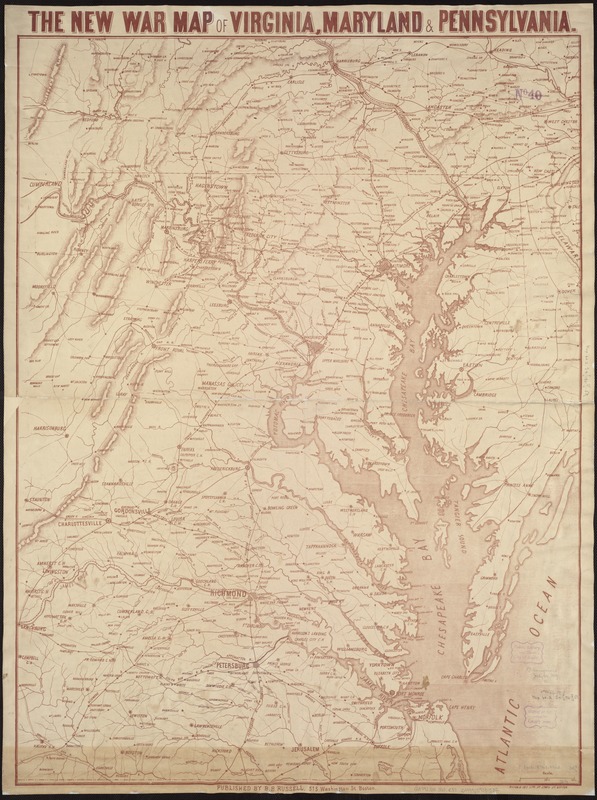
The new war map of Virginia, Maryland & Pennsylvania
The new war map of Virginia, Maryland & Pennsylvania
×
Item Information
Title:
The new war map of Virginia, Maryland & Pennsylvania
Title (alt.):
New war map of Virginia, Maryland and Pennsylvania
Creator:
Russell, B. B. (Benjamin B.)
Date:
[1860–1869]
Format:
Maps/Atlases
Location:
Boston Public Library
Norman B. Leventhal Map Center
Collection (local):
Norman B. Leventhal Map Center Collection
Subjects:
Middle Atlantic States--Maps
Virginia--Maps
Maryland--Maps
Pennsylvania--Maps
Chesapeake Bay Region (Md. and Va.)--Maps
Places:
Pennsylvania
Chesapeake Bay
Virginia
Maryland
Extent:
1 map ; 89 x 67 cm.
Permalink:
https://ark.digitalcommonwealth.org/ark:/50959/9s161j01k
Terms of Use:
No known copyright restrictions.
No known restrictions on use.
Publisher:
Boston : B.B. Russell
Language:
English
Notes:
General map of the Middle Atlantic and Chesapeake Bay regions showing railroads, highways, and selected forts in eastern Virginia. Does not show Civil War battle locations or troop positions.
Relief shown by hachures.
Printed in brown.
Notes (date):
This date is inferred.
Identifier:
06_01_007451
Call #:
G3791.S5 1860 .R87
Barcode:
39999059031532
LCCN:
91686263
show more...
View MODS XML
More Like This
Map of the country embracing the several routes examined with a ...
The Keystone group : a new railroad, post-office, township and ...
Map of the State of New York with part of the states of ...
A survey of the empire group : with a complete distance table, a ...
Find More Like This >>
Tools
Share
Facebook
Pinterest
X
Reddit
Tumblr
Email
Copy link
Add to Folder
Questions/Comments
Cite This Item
IIIF Manifest
Downloads
Primary (full resolution, uncompressed)
(TIF, 229 MB)
Large (full resolution)
(JPEG, 19.2 MB)
Medium
(JPEG, 204 KB)