Skip to search
Skip to main content
Digital Commonwealth
Sign Up / Log In
Search for
Search
Search
Search
Basic
Advanced
Explore
Map
Collections
Institutions
Formats
For Educators
Primary Source Sets
Lesson Plans
Using Primary Sources
Searching Digital Commonwealth
For Institutions
Join Digital Commonwealth
Conferences, Trainings, & Events
How to Contribute Collections
Digitization Services
Board & Committees
Frequently Asked Questions
About
About Digital Commonwealth
News & Announcements
Copyright & Terms of Use
Harmful Content Statement
Partners
API
Contact Us
Boston Public Library
Norman B. Leventhal Map Center Collection
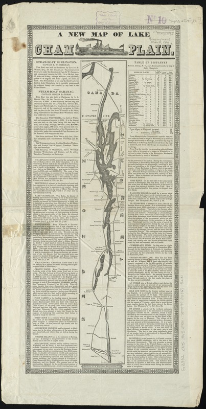
A new map of Lake Champlain
A new map of Lake Champlain
×
Item Information
Title:
A new map of Lake Champlain
Creator:
Fletcher, Stilman, 1810-1874
Date:
[1845?]
Format:
Maps/Atlases
Location:
Boston Public Library
Norman B. Leventhal Map Center
Collection (local):
Norman B. Leventhal Map Center Collection
Subjects:
Champlain, Lake--Maps
Places:
Champlain, Lake
Extent:
1 map ; 49 x 7 cm., on sheet 64 x 33 cm.
Permalink:
https://ark.digitalcommonwealth.org/ark:/50959/b8516286k
Terms of Use:
No known copyright restrictions.
No known restrictions on use.
Publisher:
Burlington, Vt : S. Fletcher
Scale:
Scale [ca. 1:680,000]
Language:
English
Notes:
Relief shown by hachures.
Includes descriptive text in columns on both sides of map.
Text references 1844 events.
Identifier:
06_01_010621
Call #:
G3802.C45 1845 .F54
Barcode:
39999065675231
show more...
View MODS XML
More Like This
Lake George, Lake Champlain, the Adirondacks
The 100th anniversary map of Abraham Lincoln's visit to ...
1630 shoreline
1879. Progress map of the U.S. Geographical Surveys west of the ...
Find More Like This >>
Tools
Share
Facebook
Pinterest
X
Reddit
Tumblr
Email
Copy link
Add to Folder
Questions/Comments
Cite This Item
IIIF Manifest
Downloads
Primary (full resolution, uncompressed)
(TIF, 90.8 MB)
Large (full resolution)
(JPEG, 7.62 MB)
Medium
(JPEG, 143 KB)