Skip to search
Skip to main content
Digital Commonwealth
Sign Up / Log In
Search for
Search
Search
Search
Basic
Advanced
Explore
Map
Collections
Institutions
Formats
For Educators
Primary Source Sets
Lesson Plans
Using Primary Sources
Searching Digital Commonwealth
For Institutions
Join Digital Commonwealth
Conferences, Trainings, & Events
How to Contribute Collections
Digitization Services
Board & Committees
Frequently Asked Questions
About
About Digital Commonwealth
News & Announcements
Copyright & Terms of Use
Harmful Content Statement
Partners
API
Contact Us
Boston Public Library
Norman B. Leventhal Map Center Collection
/
Boston and New England Maps (Collection of Distinction)
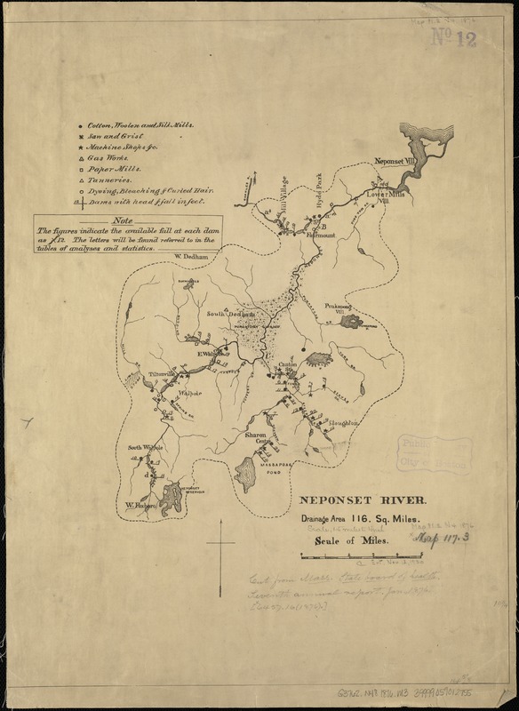
Neponset River
Neponset River
×
Item Information
Title:
Neponset River
Creator:
Massachusetts. State Board of Health
Date:
[1876]
Format:
Maps/Atlases
Location:
Boston Public Library
Norman B. Leventhal Map Center
Collection (local):
Norman B. Leventhal Map Center Collection
Subjects:
Industries--Massachusetts--Maps
Neponset River (Mass.)--Maps
Places:
Neponset
(river)
Extent:
1 map ; 49 x 37 cm.
Permalink:
https://ark.digitalcommonwealth.org/ark:/50959/js956j52v
Terms of Use:
No known copyright restrictions.
No known restrictions on use.
Publisher:
Boston? : s.n.
Scale:
Scale 1:95,040.
Language:
English
Notes:
Includes location of manufacturing/industrial establishments throughout the area.
Notes (date):
This date is inferred.
Identifier:
06_01_005308
Call #:
G3762.N48 1876 .M3
Barcode:
39999059012755
show more...
View MODS XML
More Like This
Plan of Neponset River and part of Dorchester Bay showing the ...
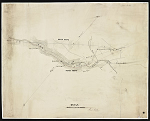
[Character conversion print errors on] Draft working map Neponset ...
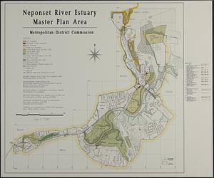
Neponset River estuary master plan area
Plan of a branch railroad at East Walpole.
Find More Like This >>
Tools
Share
Facebook
Pinterest
X
Reddit
Tumblr
Email
Copy link
Add to Folder
Questions/Comments
Cite This Item
IIIF Manifest
Downloads
Primary (full resolution, uncompressed)
(TIF, 52.6 MB)
Large (full resolution)
(JPEG, 4.41 MB)
Medium
(JPEG, 142 KB)

![[Character conversion print errors on] Draft working map Neponset River estuary](https://bpldcassets.blob.core.windows.net/derivatives/images/commonwealth:mc87v2589/image_thumbnail_300.jpg)