Skip to search
Skip to main content
Digital Commonwealth
Sign Up / Log In
Search for
Search
Search
Search
Basic
Advanced
Explore
Map
Collections
Institutions
Formats
For Educators
Primary Source Sets
Lesson Plans
Using Primary Sources
Searching Digital Commonwealth
For Institutions
Join Digital Commonwealth
Conferences, Trainings, & Events
How to Contribute Collections
Digitization Services
Board & Committees
Frequently Asked Questions
About
About Digital Commonwealth
News & Announcements
Copyright & Terms of Use
Harmful Content Statement
Partners
API
Contact Us
Boston Public Library
Norman B. Leventhal Map Center Collection
/
Urban Maps (Collection of Distinction)
/
Boston and New England Maps (Collection of Distinction)
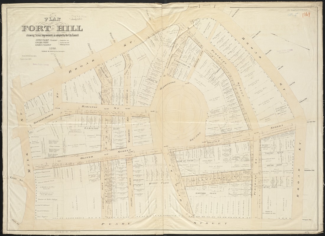
Plan of Fort Hill showing street improvements as adopted by the city council : 1869
Plan of Fort Hill showing street improvements as adopted by the city council
×
Item Information
Title:
Plan of Fort Hill showing street improvements as adopted by the city council : 1869
Creator:
Boston (Mass.). City surveyor
Name on Item:
Committee on laying and widening streets ; Thomas W. Davis.
Date:
1870
Format:
Maps/Atlases
Location:
Boston Public Library
Norman B. Leventhal Map Center
Collection (local):
Norman B. Leventhal Map Center Collection
Subjects:
Real property--Massachusetts--Boston--Maps
Land tenure--Massachusetts--Boston--Maps
Boston (Mass.)--Maps
Roxbury (Boston, Mass.)--Maps
Places:
Suffolk (county)
>
Boston
>
Roxbury
Extent:
1 map : col. ; 88 x 120 cm.
Permalink:
https://ark.digitalcommonwealth.org/ark:/50959/js956k49r
Terms of Use:
No known copyright restrictions.
No known restrictions on use.
Publisher:
Boston, Mass : [City Council?]
Scale:
Scale 1:360. 1 inch to 30 feet.
Language:
English
Notes:
Corrected 1870.
Identifier:
06_01_003493
Call #:
G3764.B6 1870 .B67
Barcode:
39999059001402
show more...
View MODS XML
More Like This
A map plat or draught of the twelve divisions of land as they were ...
Plan of a portion of the properties of the Long Wharf or Boston ...
Plan of building lots on Washington, Waltham & Parker Streets and ...
Plan of estate, nos 1043 to 1059 Washington Street, Boston, ...
Find More Like This >>
Tools
Share
Facebook
Pinterest
X
Reddit
Tumblr
Email
Copy link
Add to Folder
Questions/Comments
Cite This Item
IIIF Manifest
Downloads
Primary (full resolution, uncompressed)
(TIF, 229 MB)
Large (full resolution)
(JPEG, 19.2 MB)
Medium
(JPEG, 267 KB)