Skip to search
Skip to main content
Digital Commonwealth
Sign Up / Log In
Search for
Search
Search
Search
Basic
Advanced
Explore
Map
Collections
Institutions
Formats
For Educators
Primary Source Sets
Lesson Plans
Using Primary Sources
Searching Digital Commonwealth
For Institutions
Join Digital Commonwealth
Conferences, Trainings, & Events
How to Contribute Collections
Digitization Services
Board & Committees
Frequently Asked Questions
About
About Digital Commonwealth
News & Announcements
Copyright & Terms of Use
Harmful Content Statement
Partners
API
Contact Us
Boston Public Library
Norman B. Leventhal Map Center Collection
/
Boston and New England Maps (Collection of Distinction)
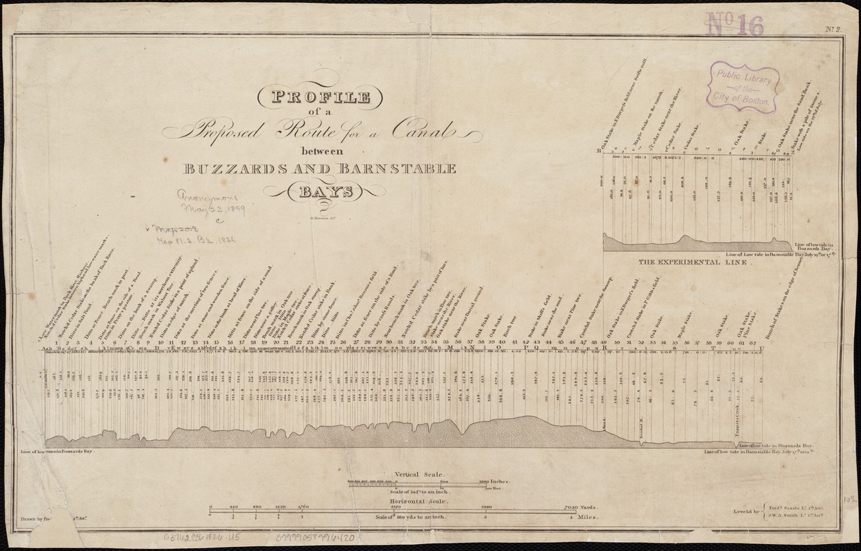
Profile of a proposed route for a canal between Buzzards and Barnstable Bays
Profile of a proposed route for a canal between Buzzards and Barnstable Bays
×
Item Information
Title:
Profile of a proposed route for a canal between Buzzards and Barnstable Bays
Name on Item:
drawn by Fre[dk. Seale] Lt. 4th Arty. ; Leveld. by Fredk. Seale Lt. 4th Arty., J.W.A. Smith, Lt. 1st Arty. ; W. Harrison sc.
Date:
[1826]
Format:
Maps/Atlases
Location:
Boston Public Library
Norman B. Leventhal Map Center
Collection (local):
Norman B. Leventhal Map Center Collection
Subjects:
Canals--Massachusetts--Cape Cod--Maps
Cape Cod Canal (Mass.)--Maps
Places:
Cape Cod Canal
Extent:
1 map ; 27 x 45 cm.
Permalink:
https://ark.digitalcommonwealth.org/ark:/50959/kk91fq88j
Terms of Use:
No known copyright restrictions.
No known restrictions on use.
Publisher:
Washington, D.C : War Dept.
Scale:
Scales differ.
Language:
English
Notes:
In upper right margin: "No. 2."
Appears in House Doc. no.174. 19th Congress, 1st session.
Shows "The Experimental Line."
Notes (date):
This date is inferred.
Identifier:
06_01_002633
Call #:
G3762.C36 1826 .P76x
Barcode:
39999058996420
show more...
View MODS XML
More Like This
Survey across the isthmus of Cape Cod, state of Massachusetts and ...
Survey of a valley and ponds auxiliary to a contemplated canal ...
Canal du Cap-Cod : plan général du tracé du canal
The 100th anniversary map of Abraham Lincoln's visit to ...
Find More Like This >>
Tools
Share
Facebook
Pinterest
X
Reddit
Tumblr
Email
Copy link
Add to Folder
Questions/Comments
Cite This Item
IIIF Manifest
Downloads
Primary (full resolution, uncompressed)
(TIF, 48.9 MB)
Large (full resolution)
(JPEG, 4.11 MB)
Medium
(JPEG, 298 KB)