Skip to search
Skip to main content
Digital Commonwealth
Sign Up / Log In
Search for
Search
Search
Search
Basic
Advanced
Explore
Map
Collections
Institutions
Formats
For Educators
Primary Source Sets
Lesson Plans
Using Primary Sources
Searching Digital Commonwealth
For Institutions
Join Digital Commonwealth
Conferences, Trainings, & Events
How to Contribute Collections
Digitization Services
Board & Committees
Frequently Asked Questions
About
About Digital Commonwealth
News & Announcements
Copyright & Terms of Use
Harmful Content Statement
Partners
API
Contact Us
Boston Public Library
Norman B. Leventhal Map Center Collection
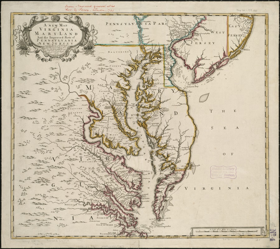
A new map of Virginia, Mary-land and the improved parts of Penn-sylvania & New Jersey
A new map of Virginia, Mary-land and the improved parts of Penn-sylvania & New Jersey
×
Item Information
Title:
A new map of Virginia, Mary-land and the improved parts of Penn-sylvania & New Jersey
Creator:
Senex, John, d. 1740
Name on Item:
most humbly inscrib'd to the Right Honble. the Earl of Orkney & ct., Knight of ye most Noble and Anciet Order of ye Thistle, 1719 ; revised by I. Senex.
Date:
[1721?]
Format:
Maps/Atlases
Location:
Boston Public Library
Norman B. Leventhal Map Center
Collection (local):
Norman B. Leventhal Map Center Collection
Subjects:
Virginia--Maps--Early works to 1800
Maryland--Maps--Early works to 1800
Pennsylvania--Maps--Early works to 1800
New Jersey--Maps--Early works to 1800
Places:
Virginia
Pennsylvania
Maryland
New Jersey
Extent:
1 map : hand col. ; 47 x 54 cm.
Permalink:
https://ark.digitalcommonwealth.org/ark:/50959/wd376176k
Terms of Use:
No known copyright restrictions.
No known restrictions on use.
Publisher:
London : s.n.
Scale:
Scale [ca. 1:840,000]
Language:
English
Notes:
Relief shown pictorially.
Prime meridian: London.
From: A new general atlas. London : D. Browne, 1721.
Identifier:
06_01_006220
Call #:
G3880 1721 .S46
Barcode:
39999059021467
show more...
View MODS XML
More Like This
A map of the country between Will's Creek & Monongahela River ...
Carte de la Virginie, du Maryland et de l'etat de Delaware
Carte de la Virginie et du Maryland
A draught of Virginia from the Capes to York in York River and to ...
Find More Like This >>
Tools
Share
Facebook
Pinterest
X
Reddit
Tumblr
Email
Copy link
Add to Folder
Questions/Comments
Cite This Item
IIIF Manifest
Downloads
Primary (full resolution, uncompressed)
(TIF, 157 MB)
Large (full resolution)
(JPEG, 13.2 MB)
Medium
(JPEG, 303 KB)