Skip to search
Skip to main content
Digital Commonwealth
Sign Up / Log In
Search for
Search
Search
Search
Basic
Advanced
Explore
Map
Collections
Institutions
Formats
For Educators
Primary Source Sets
Lesson Plans
Using Primary Sources
Searching Digital Commonwealth
For Institutions
Join Digital Commonwealth
Conferences, Trainings, & Events
How to Contribute Collections
Digitization Services
Board & Committees
Frequently Asked Questions
About
About Digital Commonwealth
News & Announcements
Copyright & Terms of Use
Harmful Content Statement
Partners
API
Contact Us
Boston Public Library
Norman B. Leventhal Map Center Collection
/
Boston and New England Maps (Collection of Distinction)
A map of Berkshire County Mass
A map of Berkshire County Mass
×
Item Information
Title:
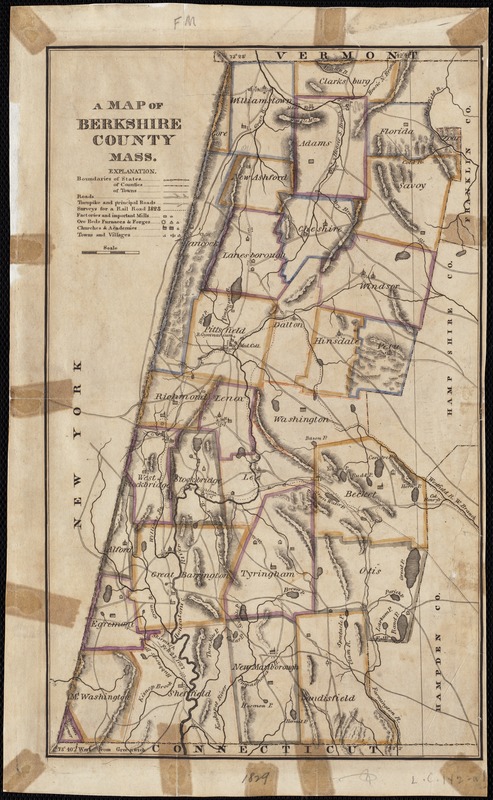
A map of Berkshire County Mass
Date:
[1830?–1840?]
Format:
Maps/Atlases
Location:
Boston Public Library
Norman B. Leventhal Map Center
Collection (local):
Norman B. Leventhal Map Center Collection
Subjects:
Berkshire County (Mass.)--Maps
Places:
Berkshire (county)
Extent:
1 map : col. ; 31 x 19 cm.
Permalink:
https://ark.digitalcommonwealth.org/ark:/50959/wd3766386
Terms of Use:
No known copyright restrictions.
No known restrictions on use.
Publisher:
S.l : s.n.
Scale:
Scale not given.
Language:
English
Notes:
Relief shown by hachures.
Identifier:
06_01_002637
Call #:
G3763.B4 1830 .M3
Barcode:
39999058996511
show more...
View MODS XML
More Like This
Atlas of Berkshire County, Massachusetts
County atlas of Berkshire Massachusetts
[Map of Berkshire County]
Map of the county of Berkshire, Massachusetts : based upon the ...
Find More Like This >>
Tools
Share
Facebook
Pinterest
X
Reddit
Tumblr
Email
Copy link
Add to Folder
Questions/Comments
Cite This Item
IIIF Manifest
Downloads
Primary (full resolution, uncompressed)
(TIF, 34.2 MB)
Large (full resolution)
(JPEG, 2.87 MB)
Medium
(JPEG, 192 KB)


![[Map of Berkshire County]](https://bpldcassets.blob.core.windows.net/derivatives/images/commonwealth:wd376641h/image_thumbnail_300.jpg)