Skip to search
Skip to main content
Digital Commonwealth
Sign Up / Log In
Search for
Search
Search
Search
Basic
Advanced
Explore
Map
Collections
Institutions
Formats
For Educators
Primary Source Sets
Lesson Plans
Using Primary Sources
Searching Digital Commonwealth
For Institutions
Join Digital Commonwealth
Conferences, Trainings, & Events
How to Contribute Collections
Digitization Services
Board & Committees
Frequently Asked Questions
About
About Digital Commonwealth
News & Announcements
Copyright & Terms of Use
Harmful Content Statement
Partners
API
Contact Us
Boston Public Library
Norman B. Leventhal Map Center Collection
/
Boston and New England Maps (Collection of Distinction)
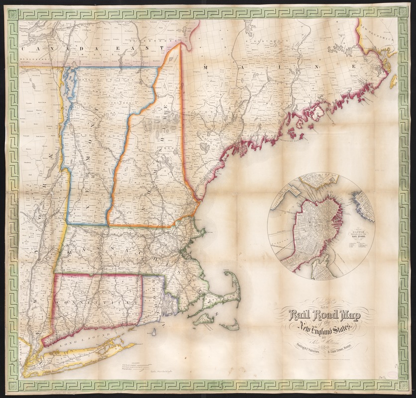
Telegraph and rail road map of the New England states
Telegraph and rail road map of the New England states
×
Item Information
Title:
Telegraph and rail road map of the New England states
Cover title :
Williams' telegraph and rail road map of the New England states
Creator:
Williams, Alexander.
Name on Item:
by Alex. Williams.
Date:
1854
Format:
Maps/Atlases
Location:
Boston Public Library
Norman B. Leventhal Map Center
Collection (local):
Norman B. Leventhal Map Center Collection
Subjects:
Railroads--New England--Maps
Telegraph lines--New England--Maps
New England--Maps
Boston (Mass.)--Maps
Places:
Suffolk (county)
>
Boston
New England
(area)
Extent:
1 map : col. ; 74 x 78 cm.
Permalink:
https://ark.digitalcommonwealth.org/ark:/50959/wd376722h
Terms of Use:
No known copyright restrictions.
No known restrictions on use.
Publisher:
Boston, Mass : Redding & Co.
Scale:
Scale ca. 1:775,000.
Language:
English
Notes:
Description derived from published bibliography.
Inset: Map of Boston showing the entrance of the Rail Roads. Circle, diameter 22 cm.
Identifier:
06_01_003042
Call #:
G3721.P3 1854 .W5
Barcode:
39999058997345
LCCN:
98688383
show more...
View MODS XML
More Like This
Lloyd's railroad, telegraph & express map of the Eastern States to ...
Map of New England exhibiting the rail road & telegraphic lines ...
Map of New England exhibiting the rail road and telegraphic lines ...
Williams' telegraph and rail road map of the New England states, ...
Find More Like This >>
Tools
Share
Facebook
Pinterest
X
Reddit
Tumblr
Email
Copy link
Add to Folder
Questions/Comments
Cite This Item
IIIF Manifest
Downloads
Primary (full resolution, uncompressed)
(TIF, 184 MB)
Large (full resolution)
(JPEG, 15.4 MB)
Medium
(JPEG, 274 KB)
GeoTIFF (georeferenced)
(TIF, 213 MB)