Skip to search
Skip to main content
Digital Commonwealth
Sign Up / Log In
Search for
Search
Search
Search
Basic
Advanced
Explore
Map
Collections
Institutions
Formats
For Educators
Primary Source Sets
Lesson Plans
Using Primary Sources
Searching Digital Commonwealth
For Institutions
Join Digital Commonwealth
Conferences, Trainings, & Events
How to Contribute Collections
Digitization Services
Board & Committees
Frequently Asked Questions
About
About Digital Commonwealth
News & Announcements
Copyright & Terms of Use
Harmful Content Statement
Partners
API
Contact Us
Boston Public Library
Norman B. Leventhal Map Center Collection
/
American Revolutionary War-Era Maps (Collection of Distinction)
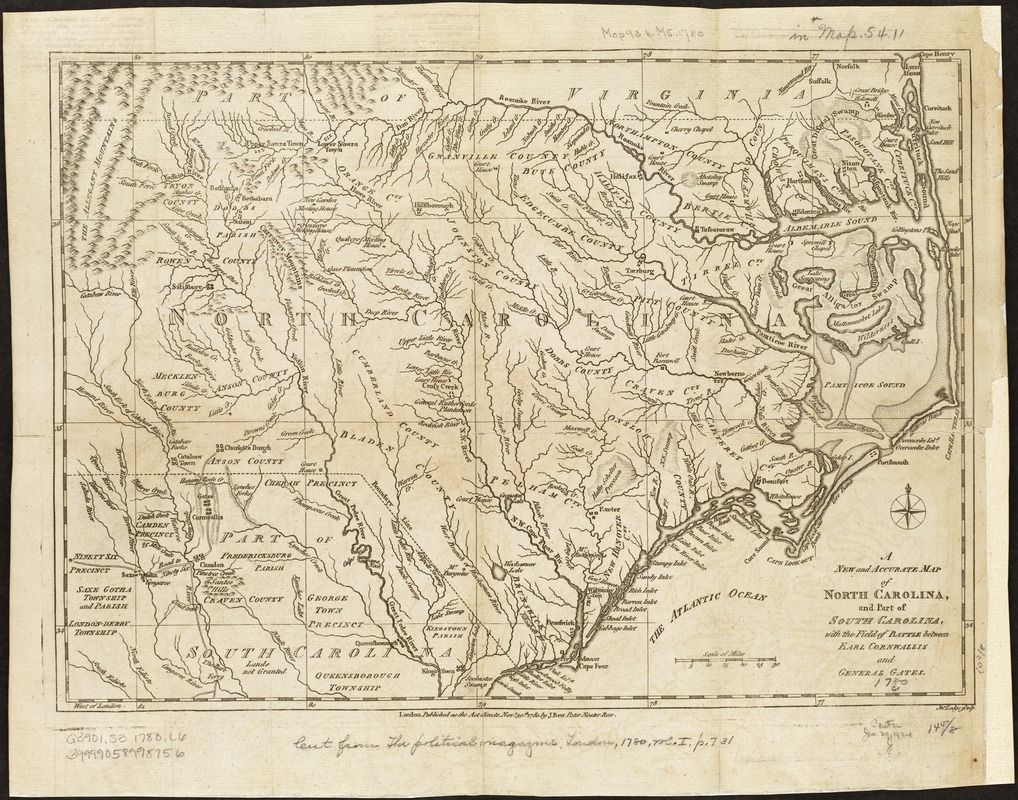
A new and accurate map of North Carolina, and part of South Carolina, with the field of battle between Earl Cornwalis and General Gates
A new and accurate map of North Carolina, and part of South Carolina, with the field of battle between Earl Cornwalis and General Gates
×
Item Information
Title:
A new and accurate map of North Carolina, and part of South Carolina, with the field of battle between Earl Cornwalis and General Gates
Creator:
Lodge, John, d. 1796
Name on Item:
Jno. Lodge sculp.
Date:
1780
Format:
Maps/Atlases
Location:
Boston Public Library
Norman B. Leventhal Map Center
Collection (local):
Norman B. Leventhal Map Center Collection
Subjects:
North Carolina--History--Revolution, 1775-1783--Maps--Early works to 1800
South Carolina--History--Revolution, 1775-1783--Maps--Early works to 1800
Places:
North Carolina
South Carolina
Extent:
1 map ; 27 x 38 cm.
Permalink:
https://ark.digitalcommonwealth.org/ark:/50959/wd376837b
Terms of Use:
No known copyright restrictions.
No known restrictions on use.
Publisher:
London : Published as the Act directs ... by J. Bew
Scale:
Scale [ca. 1:1,300,000]
Language:
English
Notes:
Relief shown pictorially.
Appears in The Political Magazine, London, 1780, vol. 1, p.731.
Identifier:
06_01_003130
Call #:
G3901.S3 1780 .L6
Barcode:
39999058998756
show more...
View MODS XML
More Like This
A map of such parts of Georgia and South Carolina as tend to ...
A plan of the attack of Fort Sulivan, the key of Charlestown, in ...
A sketch of the environs of Charlestown in South Carolina
The 100th anniversary map of Abraham Lincoln's visit to ...
Find More Like This >>
Tools
Share
Facebook
Pinterest
X
Reddit
Tumblr
Email
Copy link
Add to Folder
Questions/Comments
Cite This Item
IIIF Manifest
Downloads
Primary (full resolution, uncompressed)
(TIF, 54.1 MB)
Large (full resolution)
(JPEG, 4.54 MB)
Medium
(JPEG, 382 KB)