Skip to search
Skip to main content
Digital Commonwealth
Sign Up / Log In
Search for
Search
Search
Search
Basic
Advanced
Explore
Map
Collections
Institutions
Formats
For Educators
Primary Source Sets
Lesson Plans
Using Primary Sources
Searching Digital Commonwealth
For Institutions
Join Digital Commonwealth
Conferences, Trainings, & Events
How to Contribute Collections
Digitization Services
Board & Committees
Frequently Asked Questions
About
About Digital Commonwealth
News & Announcements
Copyright & Terms of Use
Harmful Content Statement
Partners
API
Contact Us
Boston Public Library
Norman B. Leventhal Map Center Collection
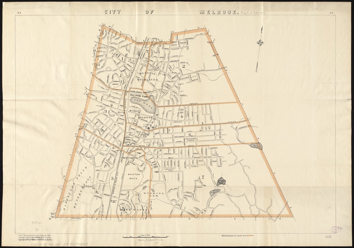
City of Melrose
City of Melrose
×
Item Information
Title:
City of Melrose
Cover title :
Latest map of Melrose city Massachusetts
Creator:
Walker Lith. & Pub. Co
Date:
[ca. 1909]
Format:
Maps/Atlases
Location:
Boston Public Library
Norman B. Leventhal Map Center
Collection (local):
Norman B. Leventhal Map Center Collection
Subjects:
Melrose (Mass.)--Administrative and political divisions--Maps
Places:
Middlesex (county)
>
Melrose
Extent:
1 map : col. ; 45 x 66 cm.
Permalink:
https://ark.digitalcommonwealth.org/ark:/50959/x059c926k
Terms of Use:
No known copyright restrictions.
No known restrictions on use.
Publisher:
Boston : Walker Lith. & Pub. Co.
Scale:
Scale [1:9,600].
Language:
English
Notes:
Oriented with north toward the upper right.
Shows ward boundaries.
Part of Massachusetts Atlas, c1904.
Has "84" and "85" in upper margin.
Identifier:
06_01_005381
Call #:
G3764.M59 1909 .W3x
Barcode:
39999059013555
show more...
View MODS XML
More Like This
The 100th anniversary map of Abraham Lincoln's visit to ...
1630 shoreline
1879. Progress map of the U.S. Geographical Surveys west of the ...
1903 Map of Salem and surrounding places
Find More Like This >>
Tools
Share
Facebook
Pinterest
X
Reddit
Tumblr
Email
Copy link
Add to Folder
Questions/Comments
Cite This Item
IIIF Manifest
Downloads
Primary (full resolution, uncompressed)
(TIF, 97.4 MB)
Large (full resolution)
(JPEG, 8.18 MB)
Medium
(JPEG, 244 KB)
GeoTIFF (georeferenced)
(TIF, 89.1 MB)