Skip to search
Skip to main content
Digital Commonwealth
Sign Up / Log In
Search for
Search
Search
Search
Basic
Advanced
Explore
Map
Collections
Institutions
Formats
For Educators
Primary Source Sets
Lesson Plans
Using Primary Sources
Searching Digital Commonwealth
For Institutions
Join Digital Commonwealth
Conferences, Trainings, & Events
How to Contribute Collections
Digitization Services
Board & Committees
Frequently Asked Questions
About
About Digital Commonwealth
News & Announcements
Copyright & Terms of Use
Harmful Content Statement
Partners
API
Contact Us
Boston Public Library
Norman B. Leventhal Map Center Collection
/
Urban Maps (Collection of Distinction)
/
Boston and New England Maps (Collection of Distinction)
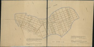
[Plan of estates on Charles River bridge, Prince Street, Lynn Court, and Snow Hill Street]
[Plan of estates on Charles River bridge, Prince Street, Lynn Court, and Snow Hill Street]
×
Item Information
Title:
[Plan of estates on Charles River bridge, Prince Street, Lynn Court, and Snow Hill Street]
Creator:
Taylor, William, 1763-1838
Date:
[1810–1820]
Format:
Maps/Atlases
Manuscripts
Location:
Boston Public Library
Norman B. Leventhal Map Center
Collection (local):
Norman B. Leventhal Map Center Collection
Subjects:
Real property--Massachusetts--Boston--Maps, Manuscript
Landowners--Massachusetts--Boston--Maps, Manuscript
North End (Boston, Mass.)--Maps, Manuscript
North End (Boston, Mass.)
Places:
Suffolk (county)
>
Boston
>
North End
Extent:
1 ms. map : col. ; on sheet 104 x 121 cm.
Permalink:
https://ark.digitalcommonwealth.org/ark:/50959/x059c960w
Terms of Use:
No known copyright restrictions.
No known restrictions on use.
Scale:
Scale not given.
Language:
English
Notes:
Title from published bibliography.
Oriented with north toward the upper left.
Shows lots and landowners.
"The property of William Taylor of Boston Surveyor."
Notes (date):
This date is inferred.
Identifier:
06_01_005398
Call #:
G3764.B6:2N5G46 1810 .T3x
Barcode:
39999059013803
show more...
View MODS XML
More Like This
Plan of Bishop Parker's estate Bedford Street
[Plan of residences on Park Street in Boston]
A plan of South Boston and the owners lands, and the roads, taken ...
Copy of an ancient plan belonging to the City (not dated probably ...
Find More Like This >>
Tools
Share
Facebook
Pinterest
X
Reddit
Tumblr
Email
Copy link
Add to Folder
Questions/Comments
Cite This Item
IIIF Manifest
Downloads
Primary (full resolution, uncompressed)
(TIF, 175 MB)
Large (full resolution)
(JPEG, 14.7 MB)
Medium
(JPEG, 188 KB)
![[Plan of estates on Charles River bridge, Prince Street, Lynn Court, and Snow Hill Street]](https://bpldcassets.blob.core.windows.net/derivatives/images/commonwealth:x059c9615/image_access_800.jpg)

![[Plan of residences on Park Street in Boston]](https://bpldcassets.blob.core.windows.net/derivatives/images/commonwealth:9s161h36g/image_thumbnail_300.jpg)