Skip to search
Skip to main content
Digital Commonwealth
Sign Up / Log In
Search for
Search
Search
Search
Basic
Advanced
Explore
Map
Collections
Institutions
Formats
For Educators
Primary Source Sets
Lesson Plans
Using Primary Sources
Searching Digital Commonwealth
For Institutions
Join Digital Commonwealth
Conferences, Trainings, & Events
How to Contribute Collections
Digitization Services
Board & Committees
Frequently Asked Questions
About
About Digital Commonwealth
News & Announcements
Copyright & Terms of Use
Harmful Content Statement
Partners
API
Contact Us
Boston Public Library
Norman B. Leventhal Map Center Collection
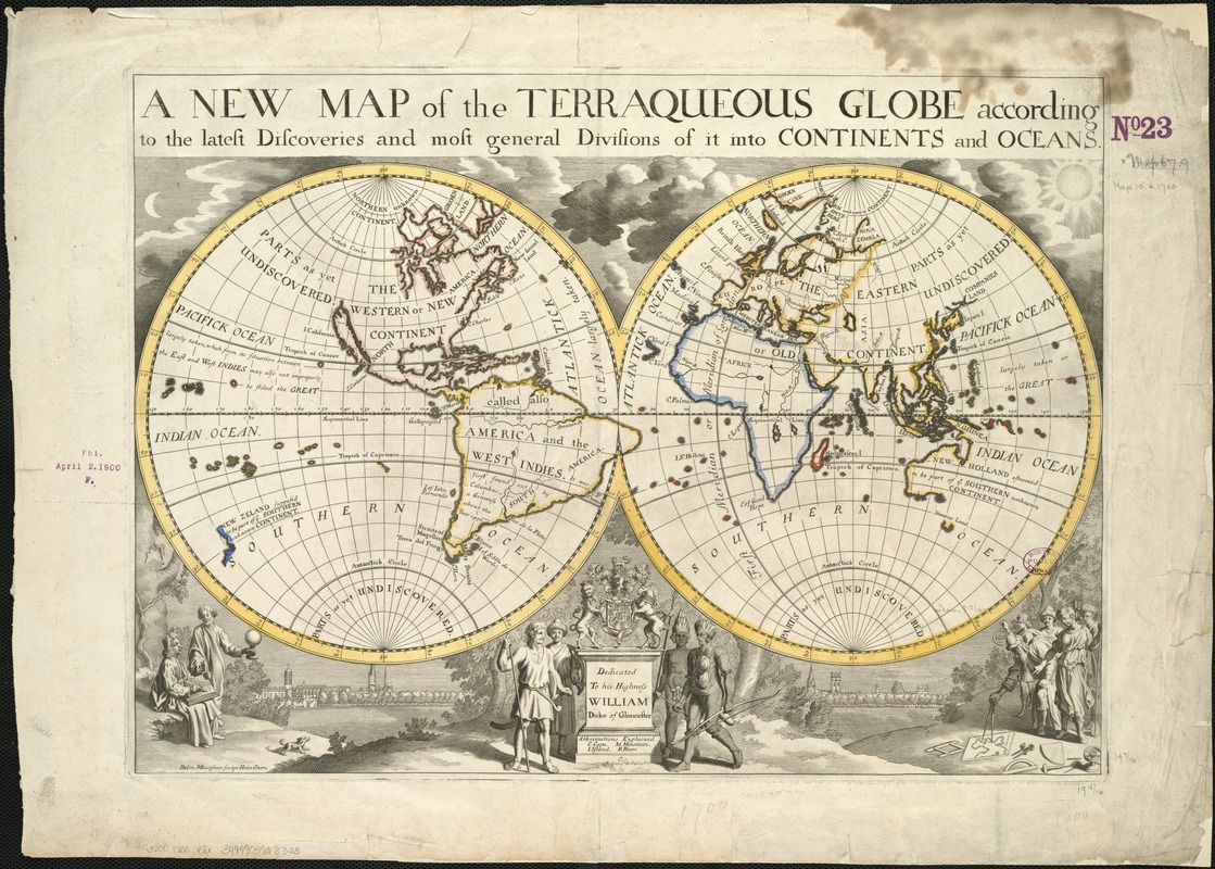
A new map of the terraqueous globe according to the latest discoveries and most general divisions of it into continents and oceans
A new map of the terraqueous globe according to the latest discoveries and most general divisions of it into continents and oceans
×
Item Information
Title:
A new map of the terraqueous globe according to the latest discoveries and most general divisions of it into continents and oceans
Creator:
Burghers, M.
Name on Item:
delin. M. Burghers ; sculp. Univ. Oxon.
Date:
[1700–1799]
Format:
Maps/Atlases
Location:
Boston Public Library
Norman B. Leventhal Map Center
Collection (local):
Norman B. Leventhal Map Center Collection
Subjects:
World maps--Early works to 1800
Places:
World
Extent:
1 map : col. ; 2 hemispheres each 25 cm. diam., on sheet 44 x 63 cm.
Permalink:
https://ark.digitalcommonwealth.org/ark:/50959/x059cd975
Terms of Use:
No known copyright restrictions.
No known restrictions on use.
Publisher:
Oxford : Edward Wells
Scale:
Scale not given.
Language:
English
Notes:
Dedicated to His Highness William Duke of Gloucester.
Notes (date):
This date is inferred.
Identifier:
06_01_005893
Call #:
G3200 1700 .B8x
Barcode:
39999059018323
show more...
View MODS XML
More Like This
Carta universal en que se contiene todo lo que del mundo se ha ...
Chart of the track of the Dolphin, Tamar, Swallow & Endeavour ...
Chart of the world according to Mercators projection, shewing the ...
A chart of the world upon Mercator's projection : describing the ...
Find More Like This >>
Tools
Share
Facebook
Pinterest
X
Reddit
Tumblr
Email
Copy link
Add to Folder
Questions/Comments
Cite This Item
IIIF Manifest
Downloads
Primary (full resolution, uncompressed)
(TIF, 152 MB)
Large (full resolution)
(JPEG, 12.8 MB)
Medium
(JPEG, 378 KB)