Skip to search
Skip to main content
Digital Commonwealth
Sign Up / Log In
Search for
Search
Search
Search
Basic
Advanced
Explore
Map
Collections
Institutions
Formats
For Educators
Primary Source Sets
Lesson Plans
Using Primary Sources
Searching Digital Commonwealth
For Institutions
Join Digital Commonwealth
Conferences, Trainings, & Events
How to Contribute Collections
Digitization Services
Board & Committees
Frequently Asked Questions
About
About Digital Commonwealth
News & Announcements
Copyright & Terms of Use
Harmful Content Statement
Partners
API
Contact Us
Boston Public Library
Norman B. Leventhal Map Center Collection
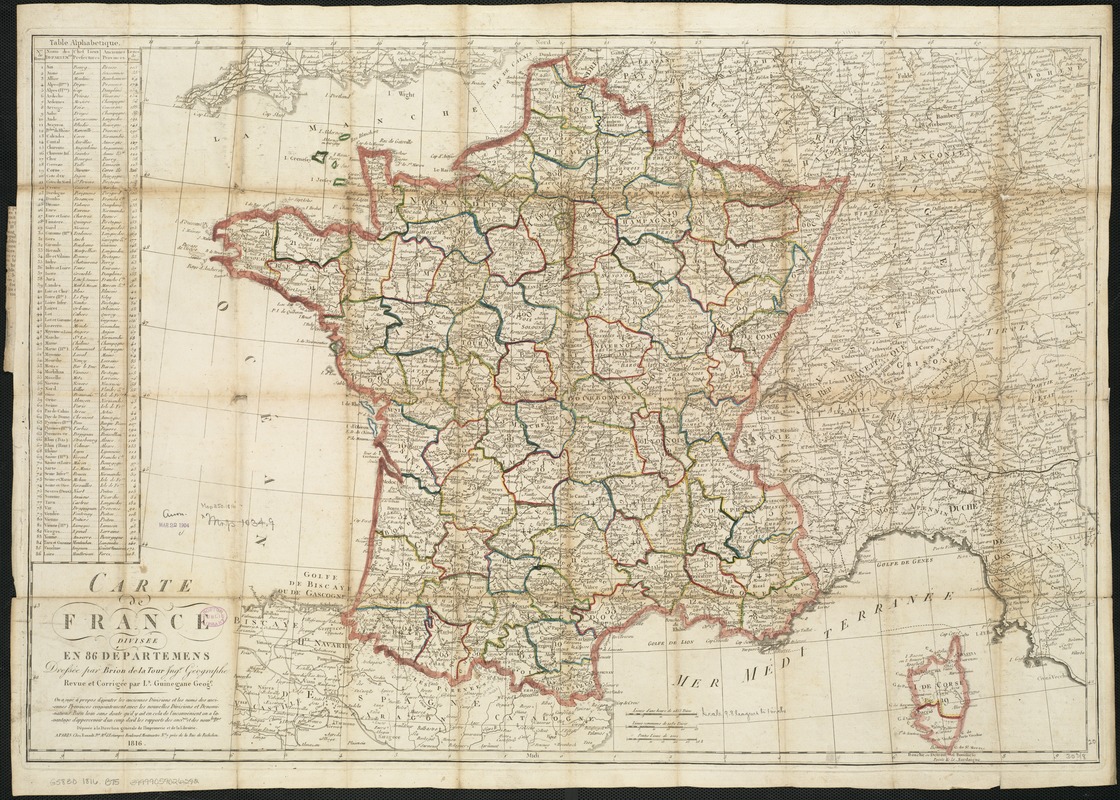
Carte de France divisée en 86 departemens
Carte de France divisée en 86 departemens
×
Item Information
Title:
Carte de France divisée en 86 departemens
Creator:
Brion de la Tour, Louis.
Name on Item:
dressée par Brion de la Tour ; revue et corrigée par Ls. Guinegane, Geoge.
Date:
1816
Format:
Maps/Atlases
Location:
Boston Public Library
Norman B. Leventhal Map Center
Collection (local):
Norman B. Leventhal Map Center Collection
Subjects:
France--Administrative and political divisions--Maps
Places:
France
Extent:
1 map : col. ; 51 x 77 cm.
Permalink:
https://ark.digitalcommonwealth.org/ark:/50959/xg94j1922
Terms of Use:
No known copyright restrictions.
No known restrictions on use.
Publisher:
A Paris : chez Esnault Jne.
Scale:
Scale ca. 1:2,060,000.
Language:
French
Notes:
Relief shown pictorially.
Includes a table of the departments.
Identifier:
06_01_006520
Call #:
G5830 1816 .B75
Barcode:
39999059026292
show more...
View MODS XML
More Like This
Carte de la France divisée en 98 départments, et subdivisée en ...
Carte itinéraire de la Républic Française divisée en ...
Deux pages d'histoire : l'ancienne Chambre dite des 363, elue les ...
France as divided into departments
Find More Like This >>
Tools
Share
Facebook
Pinterest
X
Reddit
Tumblr
Email
Copy link
Add to Folder
Questions/Comments
Cite This Item
IIIF Manifest
Downloads
Primary (full resolution, uncompressed)
(TIF, 210 MB)
Large (full resolution)
(JPEG, 17.7 MB)
Medium
(JPEG, 430 KB)
GeoTIFF (georeferenced)
(TIF, 230 MB)