Skip to search
Skip to main content
Digital Commonwealth
Sign Up / Log In
Search for
Search
Search
Search
Basic
Advanced
Explore
Map
Collections
Institutions
Formats
For Educators
Primary Source Sets
Lesson Plans
Using Primary Sources
Searching Digital Commonwealth
For Institutions
Join Digital Commonwealth
Conferences, Trainings, & Events
How to Contribute Collections
Digitization Services
Board & Committees
Frequently Asked Questions
About
About Digital Commonwealth
News & Announcements
Copyright & Terms of Use
Harmful Content Statement
Partners
API
Contact Us
Boston Public Library
Norman B. Leventhal Map Center Collection
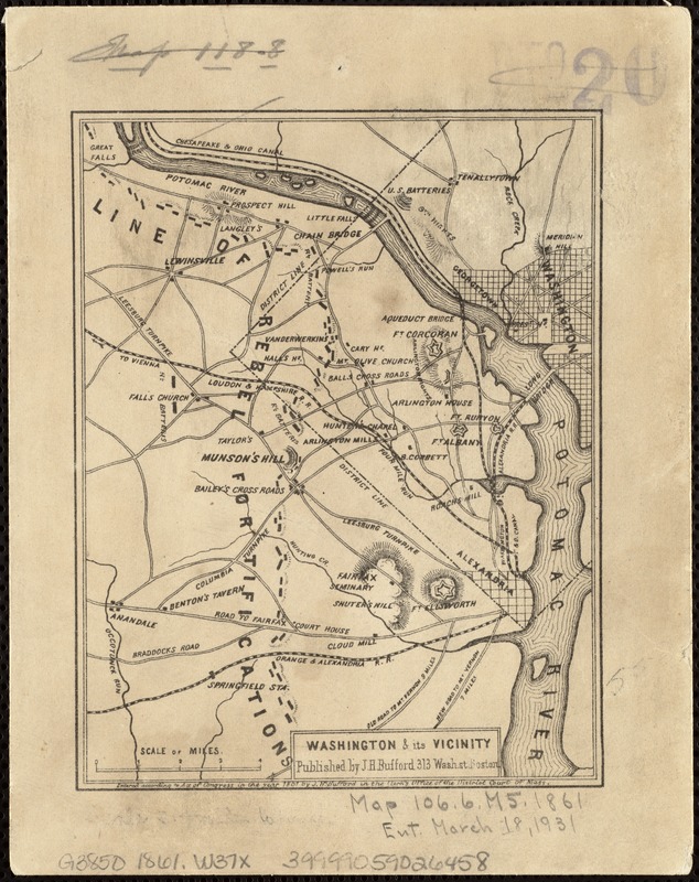
Washington & its vicinity
Washington & its vicinity
×
Item Information
Title:
Washington & its vicinity
Title (alt.):
Washington and its vicinity
Creator:
J.H. Bufford's Lith
Date:
[ca. 1861]
Format:
Maps/Atlases
Location:
Boston Public Library
Norman B. Leventhal Map Center
Collection (local):
Norman B. Leventhal Map Center Collection
Subjects:
Washington (D.C.)--History--Civil War, 1861-1865--Maps
Places:
Washington
Extent:
1 map ; 12 x 9 cm.
Permalink:
https://ark.digitalcommonwealth.org/ark:/50959/xg94j223v
Terms of Use:
No known copyright restrictions.
No known restrictions on use.
Publisher:
Boston : J.H. Bufford
Scale:
Scale ca. 1:18,100.
Language:
English
Notes:
Relief shown by hachures.
Depicts Washington, D.C. and vicinty, showing the "Line of the rebel fortifications."
Identifier:
06_01_006549
Call #:
G3850 1861 .W37x
Barcode:
39999059026458
show more...
View MODS XML
More Like This
The country round Washington : the Chesapeake and the Potomac
E. & G.W. Blunt's corrected map of Washington and the seat of war ...
Field of operations of the Army of the Potomac
Map of n. eastern Virginia and vicinity of Washington
Find More Like This >>
Tools
Share
Facebook
Pinterest
X
Reddit
Tumblr
Email
Copy link
Add to Folder
Questions/Comments
Cite This Item
IIIF Manifest
Downloads
Primary (full resolution, uncompressed)
(TIF, 18.5 MB)
Large (full resolution)
(JPEG, 1.55 MB)
Medium
(JPEG, 221 KB)