Skip to search
Skip to main content
Digital Commonwealth
Sign Up / Log In
Search for
Search
Search
Search
Basic
Advanced
Explore
Map
Collections
Institutions
Formats
For Educators
Primary Source Sets
Lesson Plans
Using Primary Sources
Searching Digital Commonwealth
For Institutions
Join Digital Commonwealth
Conferences, Trainings, & Events
How to Contribute Collections
Digitization Services
Board & Committees
Frequently Asked Questions
About
About Digital Commonwealth
News & Announcements
Copyright & Terms of Use
Harmful Content Statement
Partners
API
Contact Us
Boston Public Library
Norman B. Leventhal Map Center Collection
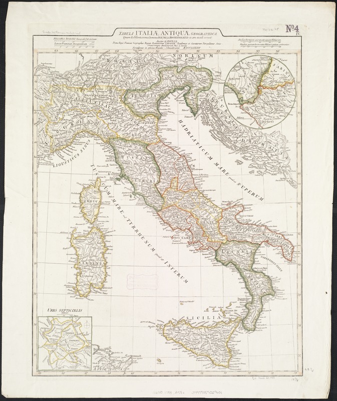
Tabula Italiae antiquae geographica : quam excellentissimus dominus Dex de la Rochefoucauld in oere incidi curavit
Tabula Italiae antiquae geographica
×
Item Information
Title:
Tabula Italiae antiquae geographica : quam excellentissimus dominus Dex de la Rochefoucauld in oere incidi curavit
Creator:
Anville, Jean Baptiste Bourguignon d', 1697-1782
Cartographer:
Anville, Jean Baptiste Bourguignon d', 1697-1782
Name on Item:
Auctor d'Anville ...
Date:
1784
Format:
Maps/Atlases
Location:
Boston Public Library
Norman B. Leventhal Map Center
Collection (local):
Norman B. Leventhal Map Center Collection
Subjects:
Classical geography--Maps--Early works to 1800
Italy--Historical geography--Maps--Early works to 1800
Places:
Italy
Extent:
1 map : outline col. ; 58 x 48 cm.
Permalink:
https://ark.digitalcommonwealth.org/ark:/50959/z890s270h
Terms of Use:
No known copyright restrictions.
No known restrictions on use.
Publisher:
Norimbergae : in Officina Weigelio-Schneideriana
Scale:
Scale [1:2,000,000].
Language:
Latin
Notes:
Inset maps: "Urbs Septicollis" ; Environs of Rome.
Shows boundaries, rivers, roads and settlements.
Relief shown pictorially.
Ferro meridian.
Italy at the time of the Romans.
Identifier:
06_01_007100
Call #:
G6710 1784 .A58x
Barcode:
39999059029601
show more...
View MODS XML
More Like This
The 100th anniversary map of Abraham Lincoln's visit to ...
1630 shoreline
1879. Progress map of the U.S. Geographical Surveys west of the ...
1903 Map of Salem and surrounding places
Find More Like This >>
Tools
Share
Facebook
Pinterest
X
Reddit
Tumblr
Email
Copy link
Add to Folder
Questions/Comments
Cite This Item
IIIF Manifest
Downloads
Primary (full resolution, uncompressed)
(TIF, 205 MB)
Large (full resolution)
(JPEG, 17.2 MB)
Medium
(JPEG, 211 KB)