Skip to search
Skip to main content
Digital Commonwealth
Sign Up / Log In
Search for
Search
Search
Search
Basic
Advanced
Explore
Map
Collections
Institutions
Formats
For Educators
Primary Source Sets
Lesson Plans
Using Primary Sources
Searching Digital Commonwealth
For Institutions
Join Digital Commonwealth
Conferences, Trainings, & Events
How to Contribute Collections
Digitization Services
Board & Committees
Frequently Asked Questions
About
About Digital Commonwealth
News & Announcements
Copyright & Terms of Use
Harmful Content Statement
Partners
API
Contact Us
Boston Public Library
Norman B. Leventhal Map Center Collection
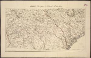
[Middle Georgia and South Carolina]
[Middle Georgia and South Carolina]
×
Item Information
Title:
[Middle Georgia and South Carolina]
Creator:
United States Coast Survey
Name on Item:
U.S. Coast Survey ; A. D. Bache Supdt.
Date:
1865
Format:
Maps/Atlases
Location:
Boston Public Library
Norman B. Leventhal Map Center
Collection (local):
Norman B. Leventhal Map Center Collection
Subjects:
Georgia--Maps
South Carolina--Maps
Places:
Georgia
South Carolina
Extent:
1 map ; 57 x 85 cm.
Permalink:
https://ark.digitalcommonwealth.org/ark:/50959/7h14b265w
Terms of Use:
No known copyright restrictions.
No known restrictions on use.
Publisher:
[Washington D.C.] : The Survey
Scale:
Scale [1:633,600].1 in. = 10 miles
Language:
English
Notes:
Relief shown by hachures.
Identifier:
06_01_008749
Call #:
G3920 1865 .U55x
Barcode:
39999065656355
show more...
View MODS XML
More Like This
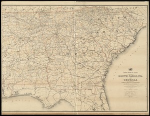
Middle Georgia & South Carolina
Post route map of the States of South Carolina and Georgia with ...
Carte de la Caroline et Georgie. : Pour servir à l'Histoire ...
Carte de la Caroline et Georgie. : Pour servir à l'Histoire ...
Find More Like This >>
Tools
Share
Facebook
Pinterest
X
Reddit
Tumblr
Email
Copy link
Add to Folder
Questions/Comments
Cite This Item
IIIF Manifest
Downloads
Primary (full resolution, uncompressed)
(TIF, 131 MB)
Large (full resolution)
(JPEG, 11 MB)
Medium
(JPEG, 463 KB)
![[Middle Georgia and South Carolina]](https://bpldcassets.blob.core.windows.net/derivatives/images/commonwealth:7h14b2665/image_access_800.jpg)