Skip to search
Skip to main content
Digital Commonwealth
Sign Up / Log In
Search for
Search
Search
Search
Basic
Advanced
Explore
Map
Collections
Institutions
Formats
For Educators
Primary Source Sets
Lesson Plans
Using Primary Sources
Searching Digital Commonwealth
For Institutions
Join Digital Commonwealth
Conferences, Trainings, & Events
How to Contribute Collections
Digitization Services
Board & Committees
Frequently Asked Questions
About
About Digital Commonwealth
News & Announcements
Copyright & Terms of Use
Harmful Content Statement
Partners
API
Contact Us
Boston Public Library
Norman B. Leventhal Map Center Collection
/
Urban Maps (Collection of Distinction)
/
American Revolutionary War-Era Maps (Collection of Distinction)
/
Boston and New England Maps (Collection of Distinction)
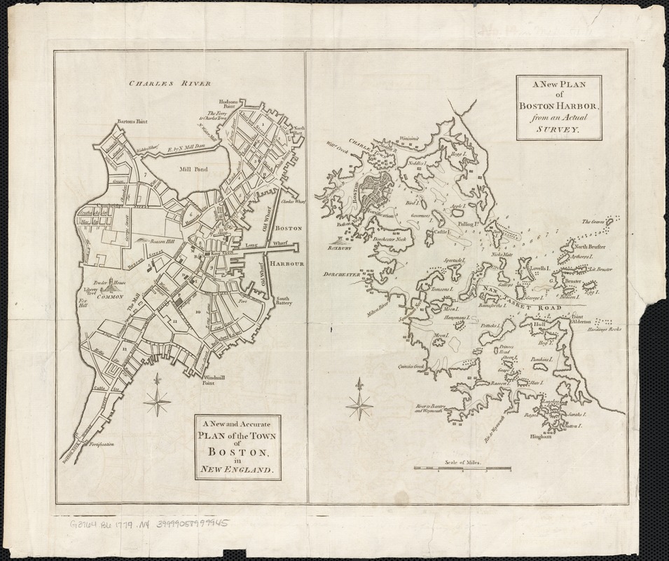
A new and accurate plan of the town of Boston in New England : A new plan of Boston Harbor from an actual survey
A new and accurate plan of the town of Boston in New England
×
Item Information
Title:
A new and accurate plan of the town of Boston in New England : A new plan of Boston Harbor from an actual survey
Title (uniform):
Universal magazine of knowledge and pleasure
Date:
[1774]
Format:
Maps/Atlases
Location:
Boston Public Library
Norman B. Leventhal Map Center
Collection (local):
Norman B. Leventhal Map Center Collection
Subjects:
Boston (Mass.)--Maps--Early works to 1800
Boston Harbor (Mass.)--Maps--Early works to 1800
Places:
Boston Harbor
Suffolk (county)
>
Boston
Extent:
2 maps on 1 sheet ; 28 x 15 cm. and 28 x 20 cm., sheet 28 x 35 cm.
Permalink:
https://ark.digitalcommonwealth.org/ark:/50959/9s1619588
Terms of Use:
No known copyright restrictions.
No known restrictions on use.
Publisher:
London : for John Hinton
Scale:
Scale not given.
Scale [ca. 1:110,000].
Language:
English
Notes:
Relief shown pictorially. Depths shown by soundings.
From: The universal magazine of knowledge and pleasure .... Vol. 54 (May 1774). p. 225.
Notes (date):
This date is inferred.
Identifier:
06_01_003270
Call #:
G3764.B6 1774 .N4
Barcode:
39999058999945
show more...
View MODS XML
More Like This
Boston, its environs and harbour, with the rebel works raised ...
Bowles's map of the seat of war in New England, comprehending the ...
Carte de la ville, baye et environs de Baston
Carte des environs de Boston, capitale de la Nlle. Angleterre en ...
Find More Like This >>
Tools
Share
Facebook
Pinterest
X
Reddit
Tumblr
Email
Copy link
Add to Folder
Questions/Comments
Cite This Item
IIIF Manifest
Downloads
Primary (full resolution, uncompressed)
(TIF, 48.9 MB)
Large (full resolution)
(JPEG, 4.11 MB)
Medium
(JPEG, 260 KB)