Skip to search
Skip to main content
Digital Commonwealth
Sign Up / Log In
Search for
Search
Search
Search
Basic
Advanced
Explore
Map
Collections
Institutions
Formats
For Educators
Primary Source Sets
Lesson Plans
Using Primary Sources
Searching Digital Commonwealth
For Institutions
Join Digital Commonwealth
Conferences, Trainings, & Events
How to Contribute Collections
Digitization Services
Board & Committees
Frequently Asked Questions
About
About Digital Commonwealth
News & Announcements
Copyright & Terms of Use
Harmful Content Statement
Partners
API
Contact Us
Boston Public Library
Norman B. Leventhal Map Center Collection
/
Urban Maps (Collection of Distinction)
/
Boston and New England Maps (Collection of Distinction)
Plan de Boston
Plan de Boston
×
Item Information
Title:
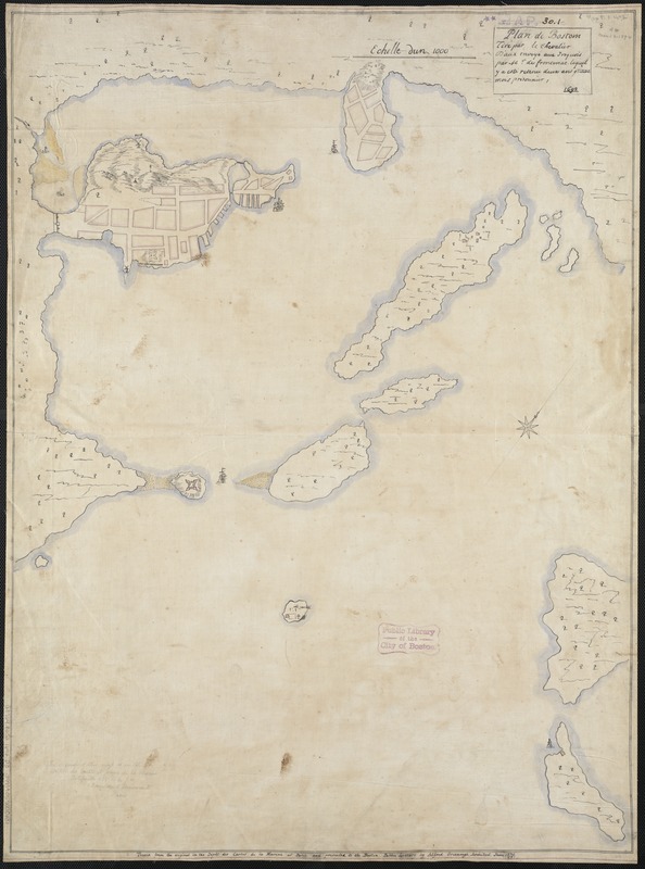
Plan de Boston
Creator:
Au de Jolliet, Pierre d', 1666-1694
Name on Item:
tiré par le Chevalier D'aux envoyé aux Iroquois par Mr. de Frontenac, lequel y a esté retenu deux ans quatre mois prisonnier, 1692.
Date:
1879
Format:
Maps/Atlases
Manuscripts
Location:
Boston Public Library
Norman B. Leventhal Map Center
Collection (local):
Norman B. Leventhal Map Center Collection
Subjects:
Fortification--Massachusetts--Boston--Maps, Manuscript--Early works to 1800
Fortification--Massachusetts--Boston Harbor Islands--Maps, Manuscript--Early works to 1800
Boston (Mass.)--Maps, Manuscript--Early works to 1800
Boston Harbor Islands (Mass.)--Maps, Manuscript--Early works to 1800
Frontenac, Louis de Buade, comte de, 1620-1698
Places:
Boston Harbor
Suffolk (county)
>
Boston
Extent:
1 ms. map : col. ; 76 x 56 cm.
Permalink:
https://ark.digitalcommonwealth.org/ark:/50959/9s161975x
Terms of Use:
No known copyright restrictions.
No known restrictions on use.
Scale:
Scale not given.
Language:
French
English
Notes:
Oriented with north toward the upper right.
"Traced from the original in the Dépôt des Cartes de la Marine at Paris and presented to the Boston Public Library by Alfred Greenough, Architect, June 1879."
Original version: 1692.
Identifier:
06_01_003293
Call #:
G3764.B6S2 1692 .A99
Barcode:
39999059000131
show more...
View MODS XML
More Like This
[Boston wharves, from Long Wharf]
[Plan of Boston neck]
The 100th anniversary map of Abraham Lincoln's visit to ...
1630 shoreline
Find More Like This >>
Tools
Share
Facebook
Pinterest
X
Reddit
Tumblr
Email
Copy link
Add to Folder
Questions/Comments
Cite This Item
IIIF Manifest
Downloads
Primary (full resolution, uncompressed)
(TIF, 216 MB)
Large (full resolution)
(JPEG, 18.1 MB)
Medium
(JPEG, 138 KB)
![[Boston wharves, from Long Wharf]](https://bpldcassets.blob.core.windows.net/derivatives/images/commonwealth:9s161966z/image_thumbnail_300.jpg)
![[Plan of Boston neck]](https://bpldcassets.blob.core.windows.net/derivatives/images/commonwealth:9s161g52n/image_thumbnail_300.jpg)

