Skip to search
Skip to main content
Digital Commonwealth
Sign Up / Log In
Search for
Search
Search
Search
Basic
Advanced
Explore
Map
Collections
Institutions
Formats
For Educators
Primary Source Sets
Lesson Plans
Using Primary Sources
Searching Digital Commonwealth
For Institutions
Join Digital Commonwealth
Conferences, Trainings, & Events
How to Contribute Collections
Digitization Services
Board & Committees
Frequently Asked Questions
About
About Digital Commonwealth
News & Announcements
Copyright & Terms of Use
Harmful Content Statement
Partners
API
Contact Us
Boston Public Library
Norman B. Leventhal Map Center Collection
/
Urban Maps (Collection of Distinction)
/
Boston and New England Maps (Collection of Distinction)
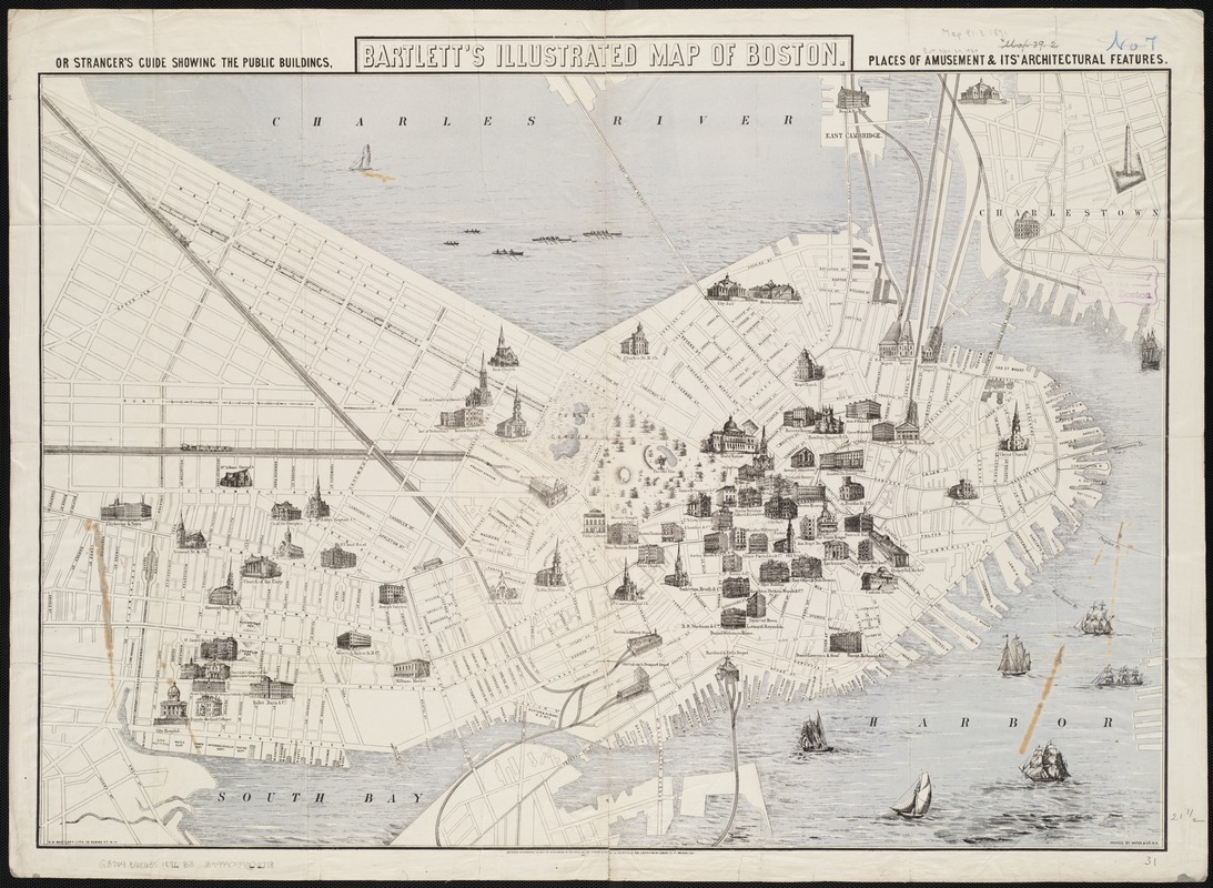
Bartlett's illustrated map of Boston, or, Stranger's guide showing the public buildings, places of amusement & its' architectural features
Bartletts illustrated map of Boston, or, Strangers guide showing the public buildings, places of amusement & its architectural features
×
Item Information
Title:
Bartlett's illustrated map of Boston, or, Stranger's guide showing the public buildings, places of amusement & its' architectural features
Title (alt.):
Stranger's guide showing the public buildings, places of amusement & its' architectural features
Bartlett's Illustrated map of Boston
Creator:
Bartlett, George Hartnell, 1838-1923
Date:
1871
Format:
Maps/Atlases
Location:
Boston Public Library
Norman B. Leventhal Map Center
Collection (local):
Norman B. Leventhal Map Center Collection
Subjects:
Boston (Mass.)--Maps
Places:
Suffolk (county)
>
Boston
Extent:
1 map : col. ; 54 x 78 cm.
Permalink:
https://ark.digitalcommonwealth.org/ark:/50959/9s161g99j
Terms of Use:
No known copyright restrictions.
No known restrictions on use.
Publisher:
New York : G.H. Bartlett
Scale:
Scale not given.
Language:
English
Notes:
Shows selected buildings pictorially.
In lower margin: Entered according to Act of Congress in the year 1871 by James S. Talbot in the Office of the Librarian of Congress at Washington.
Identifier:
06_01_004183
Call #:
G3764.B6E635 1871 .B3
Barcode:
39999059004778
show more...
View MODS XML
More Like This
Annexation map
Atlas of the city of Boston : Boston proper : from actual surveys ...
Atlas of the city of Boston : Boston proper and Back Bay : from ...
Atlas of the city of Boston : Boston proper and Back Bay : from ...
Find More Like This >>
Tools
Share
Facebook
Pinterest
X
Reddit
Tumblr
Email
Copy link
Add to Folder
Questions/Comments
Cite This Item
IIIF Manifest
Downloads
Primary (full resolution, uncompressed)
(TIF, 204 MB)
Large (full resolution)
(JPEG, 17.1 MB)
Medium
(JPEG, 326 KB)