Skip to search
Skip to main content
Digital Commonwealth
Sign Up / Log In
Search for
Search
Search
Search
Basic
Advanced
Explore
Map
Collections
Institutions
Formats
For Educators
Primary Source Sets
Lesson Plans
Using Primary Sources
Searching Digital Commonwealth
For Institutions
Join Digital Commonwealth
Conferences, Trainings, & Events
How to Contribute Collections
Digitization Services
Board & Committees
Frequently Asked Questions
About
About Digital Commonwealth
News & Announcements
Copyright & Terms of Use
Harmful Content Statement
Partners
API
Contact Us
Boston Public Library
Norman B. Leventhal Map Center Collection
/
Boston and New England Maps (Collection of Distinction)
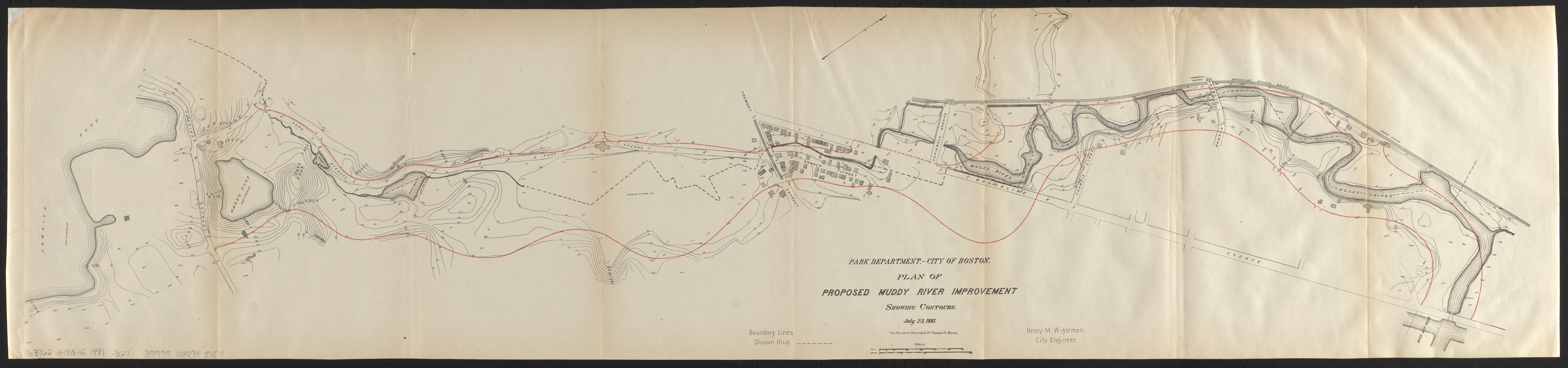
Plan of proposed Muddy River improvement, showing contours : July 23, 1881
Plan of proposed Muddy River improvement, showing contours
×
Item Information
Title:
Plan of proposed Muddy River improvement, showing contours : July 23, 1881
Publisher:
Boston (Mass.). Department of Parks
Cartographer:
Wightman, H. M.
Printer:
Heliotype Printing Co.
Name on Item:
Henry M. Wightman, city engineer
Date:
1881
Format:
Maps/Atlases
Location:
Boston Public Library
Norman B. Leventhal Map Center
Collection (local):
Norman B. Leventhal Map Center Collection
Subjects:
Parks--Massachusetts--Boston--Planning--Maps
Parks--Massachusetts--Brookline--Planning--Maps
Muddy River (Norfolk County and Suffolk County, Mass. : River)--Maps
Places:
Norfolk (county)
>
Brookline
Muddy River
Suffolk (county)
>
Boston
Extent:
1 map : color ; 22 x 94 cm
Permalink:
https://ark.digitalcommonwealth.org/ark:/50959/ht2503141
Terms of Use:
No known copyright restrictions.
No known restrictions on use.
Publisher:
[Boston] : Park Department, City of Boston
Scale:
Scale approximately 1:3,600
Language:
English
Notes:
Relief shown by contours and spot heights.
Oriented with north to the upper right.
Cut from Boston. City documents. 1882. No. 16 [6353.1.(1882).1].
Identifier:
06_01_015234
Call #:
G3762.M8G45 1881 .B67
Barcode:
39999085945754
show more...
View MODS XML
More Like This
Preliminary study of a plan for a Pleasure Bay between Dorchester ...
Suggestion for the improvement of Muddy River and for completing a ...
The 100th anniversary map of Abraham Lincoln's visit to ...
1630 shoreline
Find More Like This >>
Tools
Share
Facebook
Pinterest
X
Reddit
Tumblr
Email
Copy link
Add to Folder
Questions/Comments
Cite This Item
IIIF Manifest
Downloads
Primary (full resolution, uncompressed)
(TIF, 69.7 MB)
Large (full resolution)
(JPEG, 5.85 MB)
Medium
(JPEG, 663 KB)