Skip to search
Skip to main content
Digital Commonwealth
Sign Up / Log In
Search for
Search
Search
Search
Basic
Advanced
Explore
Map
Collections
Institutions
Formats
For Educators
Primary Source Sets
Lesson Plans
Using Primary Sources
Searching Digital Commonwealth
For Institutions
Join Digital Commonwealth
Conferences, Trainings, & Events
How to Contribute Collections
Digitization Services
Board & Committees
Frequently Asked Questions
About
About Digital Commonwealth
News & Announcements
Copyright & Terms of Use
Harmful Content Statement
Partners
API
Contact Us
Boston Public Library
Norman B. Leventhal Map Center Collection
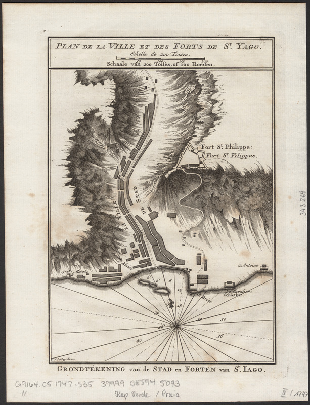
Grondtekening van de stad en forten van St. Iago = Plan de la ville et des forts de St. Yago
Grondtekening van de stad en forten van St. Iago
×
Item Information
Title:
Grondtekening van de stad en forten van St. Iago = Plan de la ville et des forts de St. Yago
Engraver:
Schley, Jacobus van der, 1715-1779
Author:
Prévost, abbé, 1697-1763
Publisher:
De Hondt, P. A. (Peter Abraham)
Name on Item:
J. v. Schley direx
Date:
[1747]
Format:
Maps/Atlases
Location:
Boston Public Library
Norman B. Leventhal Map Center
Collection (local):
Norman B. Leventhal Map Center Collection
Subjects:
Cidade Velha (Cabo Verde)--Maps--Early works to 1800
Places:
Cape Verde
>
Santiago, Ilha de
(island)
Cidade Velha
Extent:
1 map ; 19 x 15 cm
Permalink:
https://ark.digitalcommonwealth.org/ark:/50959/ht250c48h
Terms of Use:
No known copyright restrictions.
No known restrictions on use.
Publisher:
['sGravenhage] : [Pieter de Hondt]
Scale:
Scale approximately 1:6,900
Language:
Dutch
French
Notes:
Oriented with north towards the upper left.
Relief shown by shading. Depths shown by soundings.
From: Historische beschryving der reisen, volume 3, between pages 186 and 187.
In French and Dutch.
Notes (date):
This date is inferred.
Identifier:
06_01_016326
Call #:
G9164.C5 1747 .S35
Barcode:
39999085945093
show more...
View MODS XML
More Like This
The 100th anniversary map of Abraham Lincoln's visit to ...
1630 shoreline
1879. Progress map of the U.S. Geographical Surveys west of the ...
1903 Map of Salem and surrounding places
Find More Like This >>
Tools
Share
Facebook
Pinterest
X
Reddit
Tumblr
Email
Copy link
Add to Folder
Questions/Comments
Cite This Item
IIIF Manifest
Downloads
Primary (full resolution, uncompressed)
(TIF, 80.8 MB)
Large (full resolution)
(JPEG, 6.79 MB)
Medium
(JPEG, 216 KB)