Skip to search
Skip to main content
Digital Commonwealth
Sign Up / Log In
Search for
Search
Search
Search
Basic
Advanced
Explore
Map
Collections
Institutions
Formats
For Educators
Primary Source Sets
Lesson Plans
Using Primary Sources
Searching Digital Commonwealth
For Institutions
Join Digital Commonwealth
Conferences, Trainings, & Events
How to Contribute Collections
Digitization Services
Board & Committees
Frequently Asked Questions
About
About Digital Commonwealth
News & Announcements
Copyright & Terms of Use
Harmful Content Statement
Partners
API
Contact Us
Boston Public Library
Norman B. Leventhal Map Center Collection
/
Boston and New England Maps (Collection of Distinction)
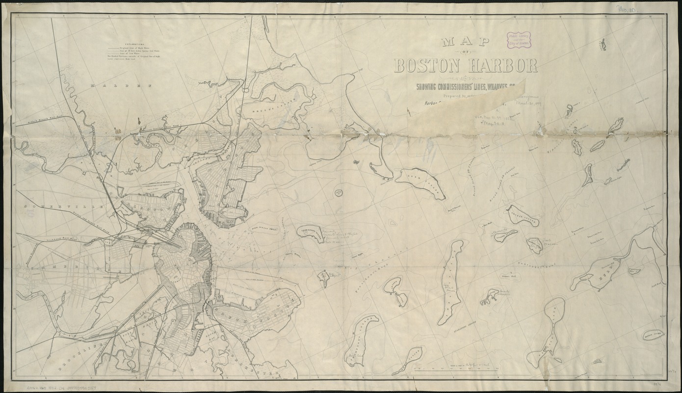
Map of Boston Harbor : showing commissioners' lines, wharves &c
Map of Boston Harbor
×
Item Information
Title:
Map of Boston Harbor : showing commissioners' lines, wharves &c
Creator:
Chesbrough, Ellis Sylvester, 1813-1886
Name on Item:
prepared by order of the Harbor Committee of the City Council of 1852 under the direction of E.S. Chesbrough, city engineer ; drawn by Charles Leonard & M.W. Nicoll.
Date:
[1852]
Format:
Maps/Atlases
Location:
Boston Public Library
Norman B. Leventhal Map Center
Collection (local):
Norman B. Leventhal Map Center Collection
Subjects:
Harbors--Massachusetts--Boston--Maps
Boston Harbor (Mass.)--Maps
Places:
Boston Harbor
Extent:
1 map ; 59 x 105 cm.
Permalink:
https://ark.digitalcommonwealth.org/ark:/50959/js956m10r
Terms of Use:
No known copyright restrictions.
No known restrictions on use.
Publisher:
Boston : Tappan & Bradford's Lith.
Scale:
Scale 1:20,340.
Language:
English
Notes:
Relief shown by contours.
Shows also original shoreline and parts of Cambridge, Charlestown, East Boston, Boston, and South Boston.
Notes (date):
This date is inferred.
Identifier:
06_01_005897
Call #:
G3762.B65 1852 .C4
Barcode:
39999059015089
show more...
View MODS XML
More Like This
Boston Bay and Harbor
Boston Harbor
Boston Harbor & vicinity
Boston Harbor, Massachusetts
Find More Like This >>
Tools
Share
Facebook
Pinterest
X
Reddit
Tumblr
Email
Copy link
Add to Folder
Questions/Comments
Cite This Item
IIIF Manifest
Downloads
Primary (full resolution, uncompressed)
(TIF, 158 MB)
Large (full resolution)
(JPEG, 13.2 MB)
Medium
(JPEG, 311 KB)
GeoTIFF (georeferenced)
(TIF, 189 MB)