Skip to search
Skip to main content
Digital Commonwealth
Sign Up / Log In
Search for
Search
Search
Search
Basic
Advanced
Explore
Map
Collections
Institutions
Formats
For Educators
Primary Source Sets
Lesson Plans
Using Primary Sources
Searching Digital Commonwealth
For Institutions
Join Digital Commonwealth
Conferences, Trainings, & Events
How to Contribute Collections
Digitization Services
Board & Committees
Frequently Asked Questions
About
About Digital Commonwealth
News & Announcements
Copyright & Terms of Use
Harmful Content Statement
Partners
API
Contact Us
Boston Public Library
Norman B. Leventhal Map Center Collection
/
American Revolutionary War-Era Maps (Collection of Distinction)
/
Boston and New England Maps (Collection of Distinction)
The state of Massachusetts from the best information
The state of Massachusetts from the best information
×
Item Information
Title:
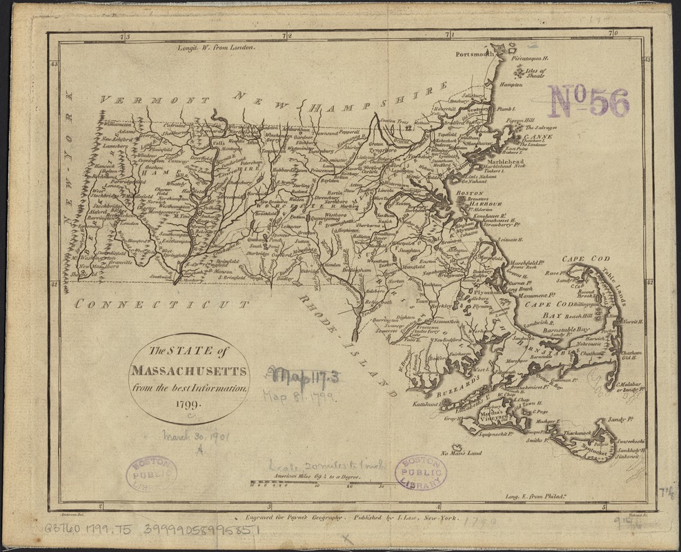
The state of Massachusetts from the best information
Name on Item:
Anderson, del. ; Tiebout sc.
Date:
1799
Format:
Maps/Atlases
Location:
Boston Public Library
Norman B. Leventhal Map Center
Collection (local):
Norman B. Leventhal Map Center Collection
Subjects:
Massachusetts--Maps--Early works to 1800
Places:
Massachusetts
Extent:
1 map ; 18 x 23 cm.
Permalink:
https://ark.digitalcommonwealth.org/ark:/50959/wd3765622
Terms of Use:
No known copyright restrictions.
No known restrictions on use.
Publisher:
New York : I. Low
Scale:
Scale [ca. 1:1,267,000]
Language:
English
Notes:
Relief shown pictorially.
Prime meridians: London and Philadelphia.
"Engraved for Payne's Geography."
Appears in A new and complete system of universal geography. New York: John Low, 1798-1800.
Identifier:
06_01_002585
Call #:
G3760 1799 .T5
Barcode:
39999058995851
show more...
View MODS XML
More Like This
An accurate map of Rhode Island, part of Connecticut and ...
An accurate map of the Commonwealth of Massachusetts exclusive of ...
An accurate map of the country round Boston in New England from ...
Carta rappresentante il porto di Boston
Find More Like This >>
Tools
Share
Facebook
Pinterest
X
Reddit
Tumblr
Email
Copy link
Add to Folder
Questions/Comments
Cite This Item
IIIF Manifest
Downloads
Primary (full resolution, uncompressed)
(TIF, 92.4 MB)
Large (full resolution)
(JPEG, 7.76 MB)
Medium
(JPEG, 324 KB)
GeoTIFF (georeferenced)
(TIF, 38.4 MB)