Skip to search
Skip to main content
Digital Commonwealth
Sign Up / Log In
Search for
Search
Search
Search
Basic
Advanced
Explore
Map
Collections
Institutions
Formats
For Educators
Primary Source Sets
Lesson Plans
Using Primary Sources
Searching Digital Commonwealth
For Institutions
Join Digital Commonwealth
Conferences, Trainings, & Events
How to Contribute Collections
Digitization Services
Board & Committees
Frequently Asked Questions
About
About Digital Commonwealth
News & Announcements
Copyright & Terms of Use
Harmful Content Statement
Partners
API
Contact Us
Boston Public Library
Norman B. Leventhal Map Center Collection
/
Boston and New England Maps (Collection of Distinction)
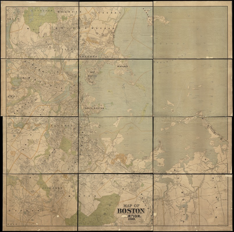
Map of Boston Harbor
Map of Boston Harbor
×
Item Information
Title:
Map of Boston Harbor
Creator:
Geo. H. Walker & Co
Date:
1899
Format:
Maps/Atlases
Location:
Boston Public Library
Norman B. Leventhal Map Center
Collection (local):
Norman B. Leventhal Map Center Collection
Subjects:
Boston Harbor (Mass.)--Maps
Boston (Mass.)--Maps
Massachusetts--Maps
Places:
Boston Harbor
Suffolk (county)
>
Boston
Extent:
1 map : col. ; 194 x 196 cm.
Permalink:
https://ark.digitalcommonwealth.org/ark:/50959/wd3768095
Terms of Use:
No known copyright restrictions.
No known restrictions on use.
Publisher:
Boston, Mass : Geo. H. Walker & Co.
Scale:
Scale [ca. 1:14,400]
Language:
English
Notes:
Oriented with north toward the upper left.
"Note: The small figures give height above City Base."
Identifier:
06_01_003105
Call #:
G3762.B65 1899 .W3
Barcode:
39999058998525
show more...
View MODS XML
More Like This
J. Schedler's relief map of Boston and environs
Map showing the terminal facilities of Boston
Boston Harbor
Chart of Boston Harbor and Massachusetts Bay : with map of the ...
Find More Like This >>
Tools
Share
Facebook
Pinterest
X
Reddit
Tumblr
Email
Copy link
Add to Folder
Questions/Comments
Cite This Item
IIIF Manifest
Downloads
Primary (full resolution, uncompressed)
(TIF, 663 MB)
Large (full resolution)
(JPEG, 55.6 MB)
Medium
(JPEG, 249 KB)