Skip to search
Skip to main content
Digital Commonwealth
Sign Up / Log In
Search for
Search
Search
Search
Basic
Advanced
Explore
Map
Collections
Institutions
Formats
For Educators
Primary Source Sets
Lesson Plans
Using Primary Sources
Searching Digital Commonwealth
For Institutions
Join Digital Commonwealth
Conferences, Trainings, & Events
How to Contribute Collections
Digitization Services
Board & Committees
Frequently Asked Questions
About
About Digital Commonwealth
News & Announcements
Copyright & Terms of Use
Harmful Content Statement
Partners
API
Contact Us
Boston Public Library
Norman B. Leventhal Map Center Collection
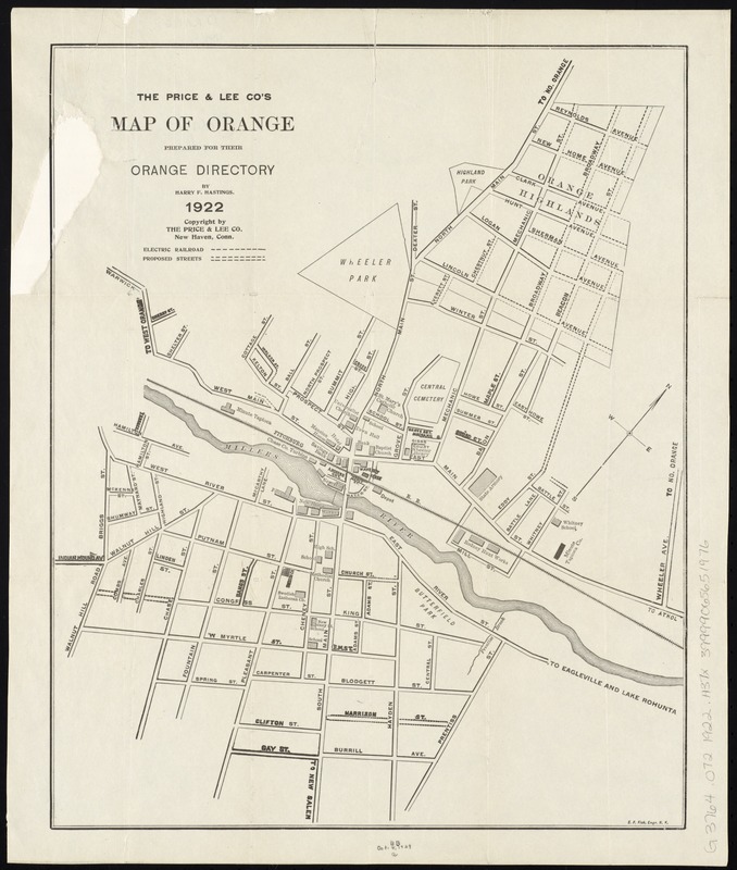
The Price & Lee Co's map of Orange
The Price & Lee Cos map of Orange
×
Item Information
Title:
The Price & Lee Co's map of Orange
Title (alt.):
Map of Orange
Creator:
Hastings, Harry F.
Name on Item:
prepared for the Orange Directory by Harry F. Hastings.
Date:
1922
Format:
Maps/Atlases
Location:
Boston Public Library
Norman B. Leventhal Map Center
Collection (local):
Norman B. Leventhal Map Center Collection
Subjects:
Orange (Mass.)--Maps
Places:
Franklin (county)
>
Orange
Extent:
1 map ; 37 x 30 cm.
Permalink:
https://ark.digitalcommonwealth.org/ark:/50959/ws859h32x
Terms of Use:
No known copyright restrictions.
No known restrictions on use.
Publisher:
New Haven, Conn : Price & Lee Co.
Scale:
Scale not given
Language:
English
Notes:
Oriented with north to the upper right.
Identifier:
06_01_008309
Call #:
G3764.O72 1922 .H37x
Barcode:
39999065651976
show more...
View MODS XML
More Like This
Atlas of the boundaries of the city of Fitchburg and towns of ...
The 100th anniversary map of Abraham Lincoln's visit to ...
1630 shoreline
1879. Progress map of the U.S. Geographical Surveys west of the ...
Find More Like This >>
Tools
Share
Facebook
Pinterest
X
Reddit
Tumblr
Email
Copy link
Add to Folder
Questions/Comments
Cite This Item
IIIF Manifest
Downloads
Primary (full resolution, uncompressed)
(TIF, 35 MB)
Large (full resolution)
(JPEG, 2.94 MB)
Medium
(JPEG, 176 KB)