Skip to search
Skip to main content
Digital Commonwealth
Sign Up / Log In
Search for
Search
Search
Search
Basic
Advanced
Explore
Map
Collections
Institutions
Formats
For Educators
Primary Source Sets
Lesson Plans
Using Primary Sources
Searching Digital Commonwealth
For Institutions
Join Digital Commonwealth
Conferences, Trainings, & Events
How to Contribute Collections
Digitization Services
Board & Committees
Frequently Asked Questions
About
About Digital Commonwealth
News & Announcements
Copyright & Terms of Use
Harmful Content Statement
Partners
API
Contact Us
Westborough Public Library
"Westborough: Your Town - Your History" Scanning Day, 2017
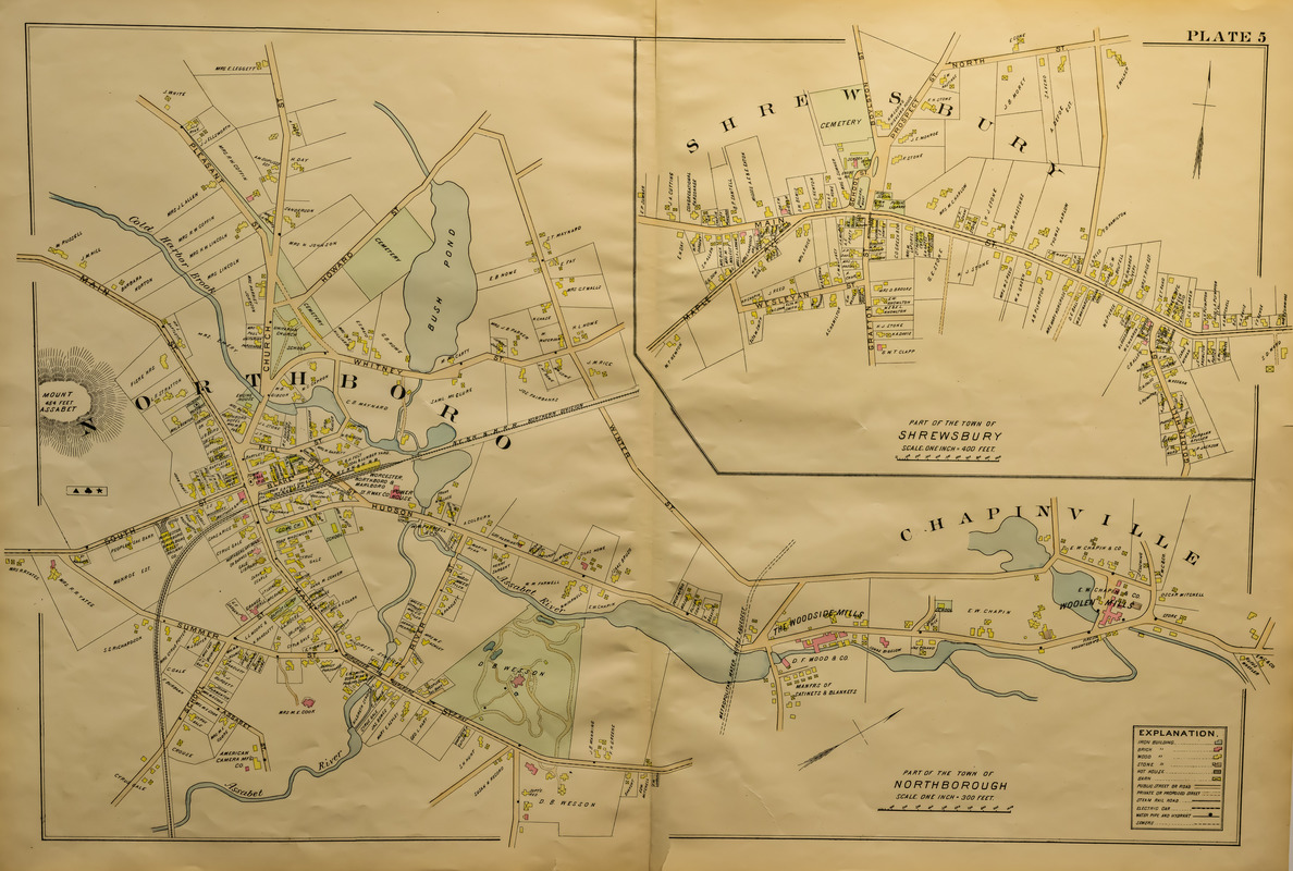
Map of part of the town of Northborough
Map of part of the town of Northborough
×
Item Information
Title:
Map of part of the town of Northborough
Description:
Plate five from an atlas. Shelby Marshall bought this from a man who had acquired it at an estate sale in Maine and she brought it to the 2017 scanning day.
Date:
[ca. 1880–1910]
Format:
Maps/Atlases
Location:
Westborough Public Library
Collection (local):
"Westborough: Your Town - Your History" Scanning Day, 2017
Places:
Massachusetts
>
Worcester (county)
>
Westborough
Extent:
1 print ; sheet 22 x 32 in.
Permalink:
https://ark.digitalcommonwealth.org/ark:/50959/z029q007z
Terms of Use:
No known copyright restrictions.
No known restrictions on use.
Language:
English
Identifier:
2017.02.019.5
show more...
View MODS XML
More Like This
100th Anniversary, 1894-1994, John Boyle O'Reilly Council #85 ...
25 West Main Street under construction
25 West Main Street under construction
89 West Main Street after the 1938 hurricane
Find More Like This >>
Tools
Share
Facebook
Pinterest
X
Reddit
Tumblr
Email
Copy link
Add to Folder
Questions/Comments
Cite This Item
Downloads
Primary (full resolution, uncompressed)
(TIF, 51.5 MB)
Large (full resolution)
(JPEG, 4.33 MB)
Medium
(JPEG, 368 KB)