Skip to search
Skip to main content
Digital Commonwealth
Sign Up / Log In
Search for
Search
Search
Search
Basic
Advanced
Explore
Map
Collections
Institutions
Formats
For Educators
Primary Source Sets
Lesson Plans
Using Primary Sources
Searching Digital Commonwealth
For Institutions
Join Digital Commonwealth
Conferences, Trainings, & Events
How to Contribute Collections
Digitization Services
Board & Committees
Frequently Asked Questions
About
About Digital Commonwealth
News & Announcements
Copyright & Terms of Use
Harmful Content Statement
Partners
API
Contact Us
Boston Public Library
Norman B. Leventhal Map Center Collection
/
Maritime Charts and Atlases (Collection of Distinction)
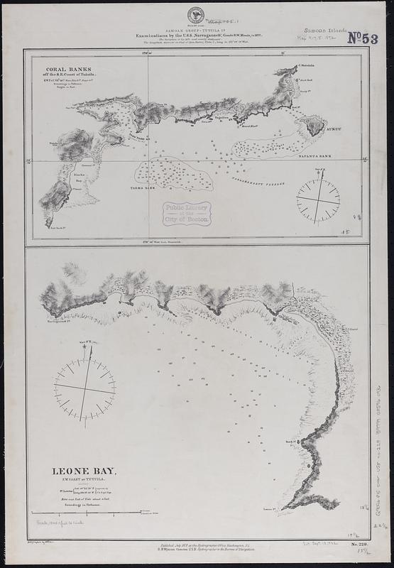
Samoan Group--Tutuila Id.
Samoan Group--Tutuila Id.
×
Item Information
Title:
Samoan Group--Tutuila Id.
Issuing body:
United States. Hydrographic Office
Surveyor:
Meade, Richard W. (Richard Worsam), 1837-1897
Name on Item:
examinations by the U.S.S. Narragansett, Comdr. R.W. Meade, in 1872
Date:
1872
Format:
Maps/Atlases
Genre:
Nautical charts
Location:
Boston Public Library
Norman B. Leventhal Map Center
Collection (local):
Norman B. Leventhal Map Center Collection
Subjects:
Tutuila Island (American Samoa)--Maps
Leone Bay (American Samoa)--Maps
Navigation--American Samoa--Tutuila Island
Navigation--American Samoa--Leone Bay
Coral reefs and islands--American Samoa--Tutuila Island--Maps
Places:
American Samoa
(territory)
>
Tutuila
(island)
American Samoa
(territory)
>
Leone
Extent:
2 maps on 1 sheet ; 57 x 40 cm
Permalink:
https://ark.digitalcommonwealth.org/ark:/50959/02873h53k
Terms of Use:
No known copyright restrictions.
No known restrictions on use.
Publisher:
Washington, D.C. : Hydrographic Office
Scale:
Scale approximately 1:14,600
Scale approximately 1:60,000
Language:
English
Table of Contents:
Coral banks off the s.e. coast of Tutuila
Leone Bay, s.w. coast of Tutuila.
Notes:
Relief shown by hachures and spot heights. Depths shown by soundings and pictorially.
Identifier:
06_01_017645
Call #:
G9096.P5 svar .U55 no. 229
Barcode:
39999085960936
show more...
View MODS XML
More Like This
Islands of Manua, Ofoo & Oloosinga, Samoan Group ; Island of ...
Bay of Massefao, island of Tutuila ; Bay of Fagaitui, island of ...
Islands of Manua, Ofoo & Oloosinga, Samoan Group ; Island of ...
The 100th anniversary map of Abraham Lincoln's visit to ...
Find More Like This >>
Tools
Share
Facebook
Pinterest
X
Reddit
Tumblr
Email
Copy link
Add to Folder
Questions/Comments
Cite This Item
IIIF Manifest
Downloads
Primary (full resolution, uncompressed)
(TIF, 120 MB)
Large (full resolution)
(JPEG, 10.1 MB)
Medium
(JPEG, 71.8 KB)