Skip to search
Skip to main content
Digital Commonwealth
Sign Up / Log In
Search for
Search
Search
Search
Basic
Advanced
Explore
Map
Collections
Institutions
Formats
For Educators
Primary Source Sets
Lesson Plans
Using Primary Sources
Searching Digital Commonwealth
For Institutions
Join Digital Commonwealth
Conferences, Trainings, & Events
How to Contribute Collections
Digitization Services
Board & Committees
Frequently Asked Questions
About
About Digital Commonwealth
News & Announcements
Copyright & Terms of Use
Harmful Content Statement
Partners
API
Contact Us
Boston Public Library
Norman B. Leventhal Map Center Collection
/
Boston and New England Maps (Collection of Distinction)
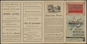
Boston & Gloucester Steamboat Co. : summer season 1889
Viewing image 1 of 2
Next >
Boston & Gloucester Steamboat Co.
×
Next
Item Information
Title:
Boston & Gloucester Steamboat Co. : summer season 1889
Title (alt.):
Boston and Gloucester Steamboat Co. : between Boston and Gloucester
Creator:
Boston & Gloucester Steamship Co.
Date:
[1889]
Format:
Prints
Location:
Boston Public Library
Norman B. Leventhal Map Center
Collection (local):
Norman B. Leventhal Map Center Collection
Subjects:
Coasts--Massachusetts--Maps
Steamboat lines--Massachusetts
Massachusetts--Description and travel
Massachusetts--Maps
Boston & Gloucester Steamship Co.
Places:
Massachusetts
Extent:
1 pamphlet ; 40 x 21 cm, folded to 21 cm
Permalink:
https://ark.digitalcommonwealth.org/ark:/50959/0r96fp956
Terms of Use:
No known copyright restrictions.
No known restrictions on use.
Publisher:
[Place of publication not identified] : [Boston & Gloucester Steamboat Co.]
Language:
English
Notes:
Pamphlet advertising the Boston & Gloucester Steamboat Co. for summer 1889.
Includes map showing the coast from Boston to Gloucester, with steamship schedule information.
Text and illustrations on verso.
Notes (date):
This date is inferred.
Identifier:
06_01_016140
06_01_016141
Call #:
HE601.B6 B37 1889
Barcode:
39999085943395
show more...
View MODS XML
More Like This
From Muskeget Channel to Buzzard's Bay and entrance to Vineyard ...
From Muskeget Channel to Buzzard's Bay and entrance to Vineyard ...
Outline map of Massachusetts showing boundaries of towns and ...
Human uses in the coastal zone : comprehensive database assembly ...
Find More Like This >>
Tools
Share
Facebook
Pinterest
X
Reddit
Tumblr
Email
Copy link
Add to Folder
Questions/Comments
Cite This Item
IIIF Manifest
Downloads
Primary (full resolution, uncompressed)
(TIF, multi-file ZIP, 72.8 MB)
Large (full resolution)
(JPEG, multi-file ZIP, 660 KB)
Medium
(JPEG, multi-file ZIP, 716 KB)