Skip to search
Skip to main content
Digital Commonwealth
Sign Up / Log In
Search for
Search
Search
Search
Basic
Advanced
Explore
Map
Collections
Institutions
Formats
For Educators
Primary Source Sets
Lesson Plans
Using Primary Sources
Searching Digital Commonwealth
For Institutions
Join Digital Commonwealth
Conferences, Trainings, & Events
How to Contribute Collections
Digitization Services
Board & Committees
Frequently Asked Questions
About
About Digital Commonwealth
News & Announcements
Copyright & Terms of Use
Harmful Content Statement
Partners
API
Contact Us
Boston Public Library
Norman B. Leventhal Map Center Collection
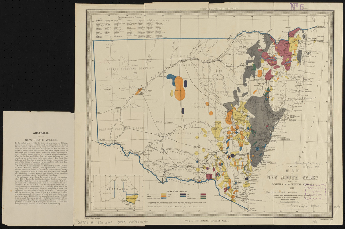
Sketch map of New South Wales showing the localities of the principal minerals 1876
Sketch map of New South Wales showing the localities of the principal minerals 1876
×
Item Information
Title:
Sketch map of New South Wales showing the localities of the principal minerals 1876
Title (alt.):
Mineral map and general statistics of New South Wales, Australia
Publisher:
New South Wales. Department of Mines
Cartographer:
Taylor, Jasper
Engraver:
Sharp, G. W.
Name on Item:
compiled and drawn by J. Taylor ; engraved by G.W. Sharp
Date:
1876
Format:
Maps/Atlases
Location:
Boston Public Library
Norman B. Leventhal Map Center
Collection (local):
Norman B. Leventhal Map Center Collection
Subjects:
Mines and mineral resources--Australia--New South Wales--Maps
New South Wales--Maps
Places:
Australia
>
New South Wales
Extent:
1 map : color ; 35 x 42 cm, folded in cover 21 x 13 cm
Permalink:
https://ark.digitalcommonwealth.org/ark:/50959/0z709864d
Terms of Use:
No known copyright restrictions.
No known restrictions on use.
Publisher:
Sydney : Thomas Richards, Government Printer
Scale:
Scale approximately 1:3,168,000
Language:
English
Notes:
Includes location map and list of proclaimed gold fields.
Text and statistics on verso.
Text on inside of front cover.
Identifier:
06_01_015410
Call #:
G8971.H1 1876 .N49
Barcode:
39999085936340
show more...
View MODS XML
More Like This
The 100th anniversary map of Abraham Lincoln's visit to ...
1630 shoreline
1879. Progress map of the U.S. Geographical Surveys west of the ...
1903 Map of Salem and surrounding places
Find More Like This >>
Tools
Share
Facebook
Pinterest
X
Reddit
Tumblr
Email
Copy link
Add to Folder
Questions/Comments
Cite This Item
IIIF Manifest
Downloads
Primary (full resolution, uncompressed)
(TIF, 52.5 MB)
Large (full resolution)
(JPEG, 4.41 MB)
Medium
(JPEG, 332 KB)