Skip to search
Skip to main content
Digital Commonwealth
Sign Up / Log In
Search for
Search
Search
Search
Basic
Advanced
Explore
Map
Collections
Institutions
Formats
For Educators
Primary Source Sets
Lesson Plans
Using Primary Sources
Searching Digital Commonwealth
For Institutions
Join Digital Commonwealth
Conferences, Trainings, & Events
How to Contribute Collections
Digitization Services
Board & Committees
Frequently Asked Questions
About
About Digital Commonwealth
News & Announcements
Copyright & Terms of Use
Harmful Content Statement
Partners
API
Contact Us
Boston Public Library
Norman B. Leventhal Map Center Collection
/
American Revolutionary War-Era Maps (Collection of Distinction)
/
Boston and New England Maps (Collection of Distinction)
/
Maritime Charts and Atlases (Collection of Distinction)
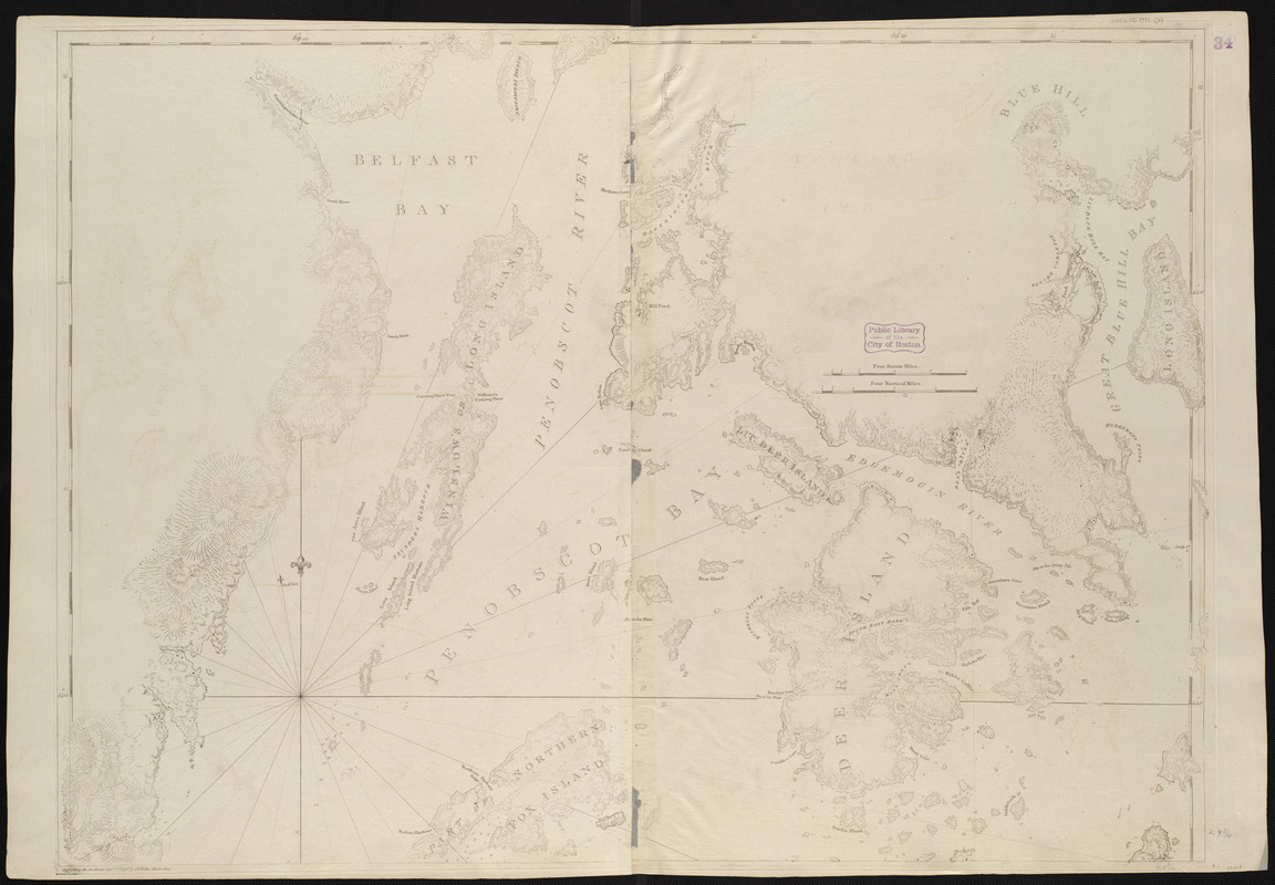
Coast of Maine showing Blue Hill Bay, Penobscot Bay, Belfast Bay, Islesboro Island, Deer Island, and other islands
Coast of Maine showing Blue Hill Bay, Penobscot Bay, Belfast Bay, Islesboro Island, Deer Island, and other islands
×
Item Information
Title:
Coast of Maine showing Blue Hill Bay, Penobscot Bay, Belfast Bay, Islesboro Island, Deer Island, and other islands
Creator:
Des Barres, Joseph F. W. (Joseph Frederick Wallet), 1722-1824
Date:
1776
Format:
Maps/Atlases
Location:
Boston Public Library
Norman B. Leventhal Map Center
Collection (local):
Norman B. Leventhal Map Center Collection
Subjects:
Coasts--Maine--Maps--Early works to 1800
Nautical charts--Maine--Early works to 1800
Atlantic Coast (Me.)--Maps--Early works to 1800
Places:
Maine
Extent:
1 chart ; 76 x 107 cm.
Permalink:
https://ark.digitalcommonwealth.org/ark:/50959/3f462w25t
Terms of Use:
No known copyright restrictions.
No known restrictions on use.
Publisher:
[London] : I.F.W. Des Barres
Edition:
1st state.
Scale:
Scale [ca. 1:48,500]
Language:
English
Notes:
Relief shown by hachures. Depths shown by soundings.
Appears in the author's Atlantic Neptune. London : J.F.W. Des Barres, 1777-[1781].
Identifier:
06_01_004976
Call #:
G1106.P5 D47 1777
Barcode:
30000003808282
show more...
View MODS XML
More Like This
Coast of Maine from Frenchman Bay to Mosquito Harbor
[Coast of Maine from Frenchman Bay to Mosquito Harbor]
Coast of Maine from Mosquito Head to Spurwink River
Coast of Maine from Mosquito Head to Spurwink River
Find More Like This >>
Tools
Share
Facebook
Pinterest
X
Reddit
Tumblr
Email
Copy link
Add to Folder
Questions/Comments
Cite This Item
IIIF Manifest
Downloads
Primary (full resolution, uncompressed)
(TIF, 218 MB)
Large (full resolution)
(JPEG, 18.3 MB)
Medium
(JPEG, 239 KB)

![[Coast of Maine from Frenchman Bay to Mosquito Harbor]](https://bpldcassets.blob.core.windows.net/derivatives/images/commonwealth:cj82m295n/image_thumbnail_300.jpg)

