Boston Public LibraryNorman B. Leventhal Map Center Collection / American Revolutionary War-Era Maps (Collection of Distinction) / Boston and New England Maps (Collection of Distinction) / Maritime Charts and Atlases (Collection of Distinction)
Falmouth Harbour
Item Information
- Title:
- Falmouth Harbour
- Description:
-
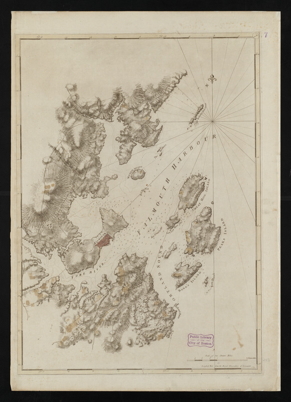
Des Barres' second state of the Falmouth Harbour chart is displayed here. This state differs from the first with the addition of dark relief shading to emphasize the topography, and the addition of soundings (measurements of depths) in the harbor. The tall pines which grew in the Maine forest were perfect for fashioning into ships' masts, and numerous sawmills were established around the region. Inland lumber was transported to the docks via "mast-roads," and roads leading to the port are illustrated in this second edition. Ultimately, Falmouth was destroyed by the British in October 1775, in an act of retaliation for a deadly uprising by the colonists at Machias, Maine, four months earlier.
- Creator:
- Des Barres, Joseph F. W. (Joseph Frederick Wallet), 1722-1824
- Date:
-
[1770–1779]
- Format:
-
Maps/Atlases
- Location:
-
Boston Public Library
Norman B. Leventhal Map Center - Collection (local):
-
Norman B. Leventhal Map Center Collection
- Subjects:
-
Nautical charts--Maine--Portland Harbor--Early works to 1800
Portland Harbor (Me.)--Maps--Early works to 1800
- Places:
-
Cumberland (county) > Portland Harbor
- Extent:
- 1 chart : hand col. ; 75 x 54 cm.
- Permalink:
- https://ark.digitalcommonwealth.org/ark:/50959/3f463954x
- Terms of Use:
-
No known copyright restrictions.
No known restrictions on use.
- Publisher:
-
London :
J.F.W. Des Barres
- Edition:
- 2nd state.
- Scale:
-
Scale [ca. 1:24,900]
- Language:
-
English
- Notes:
-
Title from published bibliography.
Relief shown by hachures. Depths shown by soundings.
Plate number "7" engraved in small oval in upper right corner.
From Charts of the coast and harbors of New England by Des Barres.
Also appears in the author's Atlantic Neptune.
- Notes (date):
-
This date is inferred.
- Notes (exhibitions):
-
Exhibited: "Charting an Empire: The Atlantic Neptune" organized by the Norman B. Leventhal Map Center at the Boston Public Library, 2013.
- Identifier:
-
06_01_004472
- Call #:
-
G1106.P5 D47 1781
- Barcode:
-
30000003813617
Downloads
- Primary (full resolution, uncompressed)(TIF, 126 MB)
- Large (full resolution)(JPEG, 10.6 MB)
- Medium(JPEG, 167 KB)