Skip to search
Skip to main content
Digital Commonwealth
Sign Up / Log In
Search for
Search
Search
Search
Basic
Advanced
Explore
Map
Collections
Institutions
Formats
For Educators
Primary Source Sets
Lesson Plans
Using Primary Sources
Searching Digital Commonwealth
For Institutions
Join Digital Commonwealth
Conferences, Trainings, & Events
How to Contribute Collections
Digitization Services
Board & Committees
Frequently Asked Questions
About
About Digital Commonwealth
News & Announcements
Copyright & Terms of Use
Harmful Content Statement
Partners
API
Contact Us
Boston Public Library
Norman B. Leventhal Map Center Collection
/
Maritime Charts and Atlases (Collection of Distinction)
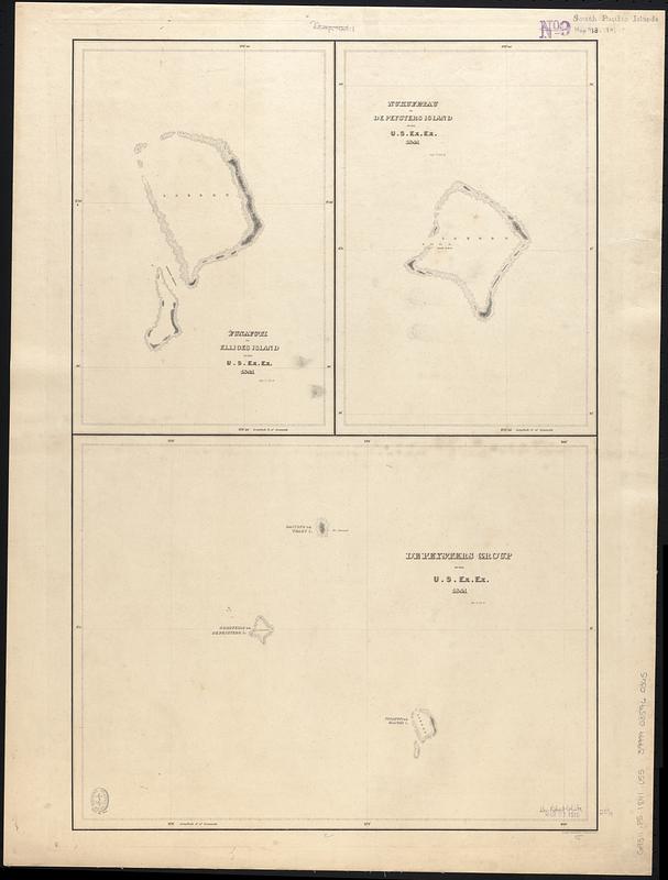
Funafuti or Ellices Island ; Nukufetau or De Peysters Island ; De Peysters Group
Funafuti or Ellices Island ; Nukufetau or De Peysters Island ; De Peysters Group
×
Item Information
Title:
Funafuti or Ellices Island ; Nukufetau or De Peysters Island ; De Peysters Group
Contributor:
Wilkes, Charles, 1798-1877
Engraver:
Sherman & Smith
Cartographer:
United States Exploring Expedition (1838-1842)
Name on Item:
by U.S. Ex. Ex. 1841 ; eng. by Sherman & Smith
Date:
[1840–1849]
Format:
Maps/Atlases
Genre:
Nautical charts
Location:
Boston Public Library
Norman B. Leventhal Map Center
Collection (local):
Norman B. Leventhal Map Center Collection
Subjects:
Funafuti Atoll (Tuvalu)--Maps
Nukufetau (Tuvalu)--Maps
Nautical charts--Tuvalu--Funafuti Atoll
Nautical charts--Tuvalu--Nukufetau
Places:
Tuvalu
>
Funafuti
(island)
Tuvalu
>
Nukufetau Atoll
Extent:
3 maps on 1 sheet ; 61 x 40 cm
Permalink:
https://ark.digitalcommonwealth.org/ark:/50959/3x819352v
Terms of Use:
No known copyright restrictions.
No known restrictions on use.
Scale:
Scale approximately 1:150,000
Scale approximately 1:150,000
Scale approximately 1:750,000
Language:
English
Table of Contents:
Funafuti or Ellices Island
Nukufetau or De Peysters Island
De Peysters Group
Notes:
Depths shown by soundings and pictorially.
Published in Narrative of the United States Exploring Expedition : during the years 1838, 1839, 1840, 1841, 1842.
Notes (date):
This date is inferred.
Identifier:
06_01_017524
Call #:
G9511.P5 1841 .U55
Barcode:
39999085960365
show more...
View MODS XML
More Like This
Funafuti or Ellice Island ; Nukufetau or De Peysters Island ; ...
The 100th anniversary map of Abraham Lincoln's visit to ...
1630 shoreline
1879. Progress map of the U.S. Geographical Surveys west of the ...
Find More Like This >>
Tools
Share
Facebook
Pinterest
X
Reddit
Tumblr
Email
Copy link
Add to Folder
Questions/Comments
Cite This Item
IIIF Manifest
Downloads
Primary (full resolution, uncompressed)
(TIF, 130 MB)
Large (full resolution)
(JPEG, 10.9 MB)
Medium
(JPEG, 60.8 KB)