Skip to search
Skip to main content
Digital Commonwealth
Sign Up / Log In
Search for
Search
Search
Search
Basic
Advanced
Explore
Map
Collections
Institutions
Formats
For Educators
Primary Source Sets
Lesson Plans
Using Primary Sources
Searching Digital Commonwealth
For Institutions
Join Digital Commonwealth
Conferences, Trainings, & Events
How to Contribute Collections
Digitization Services
Board & Committees
Frequently Asked Questions
About
About Digital Commonwealth
News & Announcements
Copyright & Terms of Use
Harmful Content Statement
Partners
API
Contact Us
Boston Public Library
Norman B. Leventhal Map Center Collection
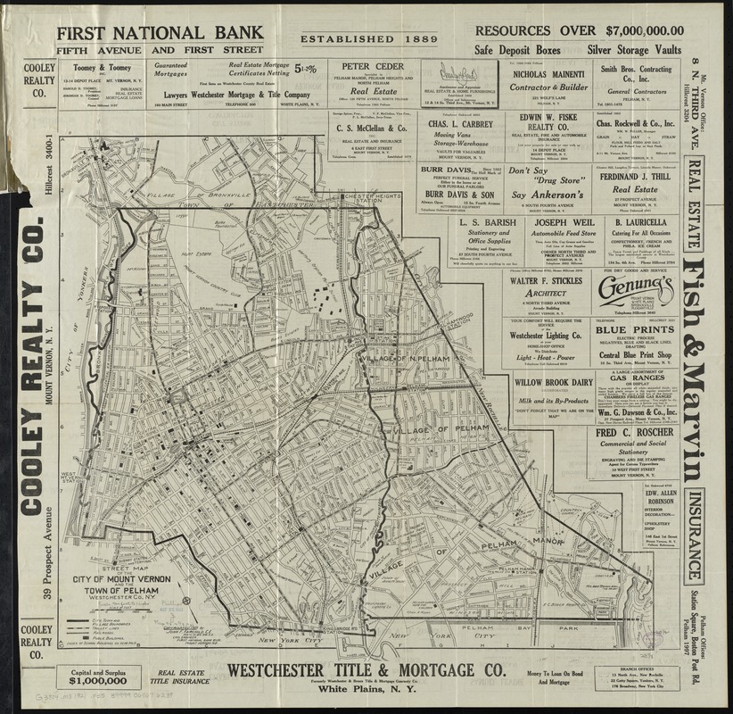
Street map of the city of Mount Vernon and the town of Pelham, Westchester County, N.Y
Street map of the city of Mount Vernon and the town of Pelham, Westchester County, N.Y
×
Item Information
Title:
Street map of the city of Mount Vernon and the town of Pelham, Westchester County, N.Y
Creator:
Fairchild, John F.
Name on Item:
John F. Fairchild, C.E.
Date:
[ca. 1921]
Format:
Maps/Atlases
Location:
Boston Public Library
Norman B. Leventhal Map Center
Collection (local):
Norman B. Leventhal Map Center Collection
Subjects:
Railroads--New York (State)--Mount Vernon (Westchester County)--Maps
Railroads--New York (State)--Pelham (Town)--Maps
Street-railroads--New York (State)--Mount Vernon (Westchester County)--Maps
Street-railroads--New York (State)--Pelham (Town)--Maps
Mount Vernon (Westchester County, N.Y.)--Maps
Pelham (N.Y. : Town)--Maps
Mount Vernon (Westchester County, N.Y.)--Administrative and political divisions--Maps
Places:
Westchester (county)
>
Mount Vernon
Westchester (county)
>
Pelham
Extent:
1 map ; 54 x 61 cm., folded in cover 19 x 11 cm.
Permalink:
https://ark.digitalcommonwealth.org/ark:/50959/4m90f237m
Terms of Use:
No known copyright restrictions.
No known restrictions on use.
Publisher:
Mount Vernon, N.Y : John F. Fairchild
Edition:
4th ed.
Scale:
Scale [ca. 1:10,400]
Language:
English
Notes:
Shows district boundaries, trolley lines, railroads, and prominent buildings.
Oriented with north towards the upper left.
Includes advertisements.
Indexes and advertisements on verso.
Edition statement from cover.
Identifier:
06_01_010707
Call #:
G3804.M8 1921 .F35
Barcode:
39999065676239
show more...
View MODS XML
More Like This
The 100th anniversary map of Abraham Lincoln's visit to ...
1630 shoreline
1879. Progress map of the U.S. Geographical Surveys west of the ...
1903 Map of Salem and surrounding places
Find More Like This >>
Tools
Share
Facebook
Pinterest
X
Reddit
Tumblr
Email
Copy link
Add to Folder
Questions/Comments
Cite This Item
IIIF Manifest
Downloads
Primary (full resolution, uncompressed)
(TIF, 192 MB)
Large (full resolution)
(JPEG, 16.1 MB)
Medium
(JPEG, 311 KB)