Skip to search
Skip to main content
Digital Commonwealth
Sign Up / Log In
Search for
Search
Search
Search
Basic
Advanced
Explore
Map
Collections
Institutions
Formats
For Educators
Primary Source Sets
Lesson Plans
Using Primary Sources
Searching Digital Commonwealth
For Institutions
Join Digital Commonwealth
Conferences, Trainings, & Events
How to Contribute Collections
Digitization Services
Board & Committees
Frequently Asked Questions
About
About Digital Commonwealth
News & Announcements
Copyright & Terms of Use
Harmful Content Statement
Partners
API
Contact Us
Boston Public Library
Norman B. Leventhal Map Center Collection
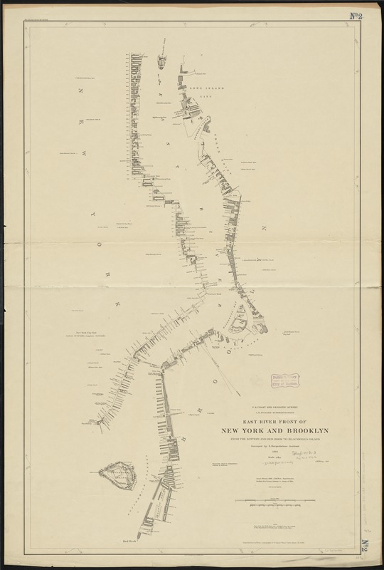
East River front of New York and Brooklyn from the Battery and Red Hook to Blackwell's Island
East River front of New York and Brooklyn from the Battery and Red Hook to Blackwells Island
×
Item Information
Title:
East River front of New York and Brooklyn from the Battery and Red Hook to Blackwell's Island
Creator:
U.S. Coast and Geodetic Survey
Name on Item:
surveyed by E. Hergesheimer Assistant ; topography inked by E. Hergesheimer ; lettering by E.H. Fowler ; J.H. Gray, aid.
Date:
1886
Format:
Maps/Atlases
Location:
Boston Public Library
Norman B. Leventhal Map Center
Collection (local):
Norman B. Leventhal Map Center Collection
Subjects:
East River (N.Y.)--Maps
Places:
New York
East River
Extent:
1 map ; 105 x 66 cm.
Permalink:
https://ark.digitalcommonwealth.org/ark:/50959/4m90f277k
Terms of Use:
No known copyright restrictions.
No known restrictions on use.
Publisher:
[Washington] : U.S. Coast & Geodetic Survey
Edition:
Issued Feb. 1886.
Scale:
Scale 1:10,000
Language:
English
Notes:
Oriented with north toward upper left corner.
Shows streets, buildings and docks along the waterfront areas only.
"Reproduction by photo lithograph of original plane table sheet No. 1586."
Identifier:
06_01_010728
Call #:
G3802.E35 1886 .U83
Barcode:
39999065676163
show more...
View MODS XML
More Like This
The 100th anniversary map of Abraham Lincoln's visit to ...
1630 shoreline
1879. Progress map of the U.S. Geographical Surveys west of the ...
1903 Map of Salem and surrounding places
Find More Like This >>
Tools
Share
Facebook
Pinterest
X
Reddit
Tumblr
Email
Copy link
Add to Folder
Questions/Comments
Cite This Item
IIIF Manifest
Downloads
Primary (full resolution, uncompressed)
(TIF, 298 MB)
Large (full resolution)
(JPEG, 25 MB)
Medium
(JPEG, 93.8 KB)