Skip to search
Skip to main content
Digital Commonwealth
Sign Up / Log In
Search for
Search
Search
Search
Basic
Advanced
Explore
Map
Collections
Institutions
Formats
For Educators
Primary Source Sets
Lesson Plans
Using Primary Sources
Searching Digital Commonwealth
For Institutions
Join Digital Commonwealth
Conferences, Trainings, & Events
How to Contribute Collections
Digitization Services
Board & Committees
Frequently Asked Questions
About
About Digital Commonwealth
News & Announcements
Copyright & Terms of Use
Harmful Content Statement
Partners
API
Contact Us
Boston Public Library
Norman B. Leventhal Map Center Collection
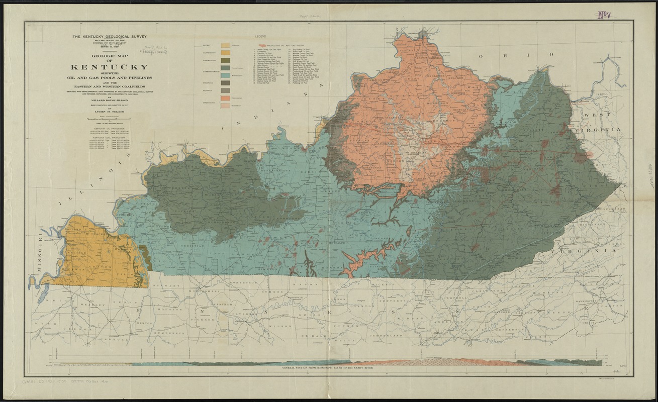
Geologic map of Kentucky : showing oil and gas pools and pipelines and the eastern and western coalfields
Geologic map of Kentucky
×
Item Information
Title:
Geologic map of Kentucky : showing oil and gas pools and pipelines and the eastern and western coalfields
Creator:
Jillson, Willard Rouse, 1890-1975
Name on Item:
by Willard Rouse Jillson ; base computed and drafted in 1917 by Lucien M. Sellier ; Kentucky Geological Survey.
Date:
1920
Format:
Maps/Atlases
Location:
Boston Public Library
Norman B. Leventhal Map Center
Collection (local):
Norman B. Leventhal Map Center Collection
Subjects:
Geology--Kentucky--Maps
Petroleum--Kentucky--Maps
Natural gas--Kentucky--Maps
Coal--Kentucky--Maps
Places:
Kentucky
Extent:
1 map : col. ; 65 x 99 cm., on sheet 72 x 98 cm.
Permalink:
https://ark.digitalcommonwealth.org/ark:/50959/4m90f6454
Terms of Use:
No known copyright restrictions.
No known restrictions on use.
Publisher:
[Frankfort, Ky.?] : Kentucky Geological Survey
Scale:
Scale [1:633,600]. 1 in. = 10 mi.
Language:
English
Notes:
Includes index of productive oil and gas fields, 1 cross section, and statistics for oil and coal production.
"Geologic and developmental data prepared by the Kentucky Geological Survey and revised, expanded, and corrected to June 1920."
Identifier:
06_01_011042
Call #:
G3951.C5 1920 .J55
Barcode:
39999065681908
show more...
View MODS XML
More Like This
Preliminary map of Kentucky
State of Kentucky coal fields and producing districts
The 100th anniversary map of Abraham Lincoln's visit to ...
1630 shoreline
Find More Like This >>
Tools
Share
Facebook
Pinterest
X
Reddit
Tumblr
Email
Copy link
Add to Folder
Questions/Comments
Cite This Item
IIIF Manifest
Downloads
Primary (full resolution, uncompressed)
(TIF, 285 MB)
Large (full resolution)
(JPEG, 23.9 MB)
Medium
(JPEG, 326 KB)