Skip to search
Skip to main content
Digital Commonwealth
Sign Up / Log In
Search for
Search
Search
Search
Basic
Advanced
Explore
Map
Collections
Institutions
Formats
For Educators
Primary Source Sets
Lesson Plans
Using Primary Sources
Searching Digital Commonwealth
For Institutions
Join Digital Commonwealth
Conferences, Trainings, & Events
How to Contribute Collections
Digitization Services
Board & Committees
Frequently Asked Questions
About
About Digital Commonwealth
News & Announcements
Copyright & Terms of Use
Harmful Content Statement
Partners
API
Contact Us
Boston Public Library
Norman B. Leventhal Map Center Collection
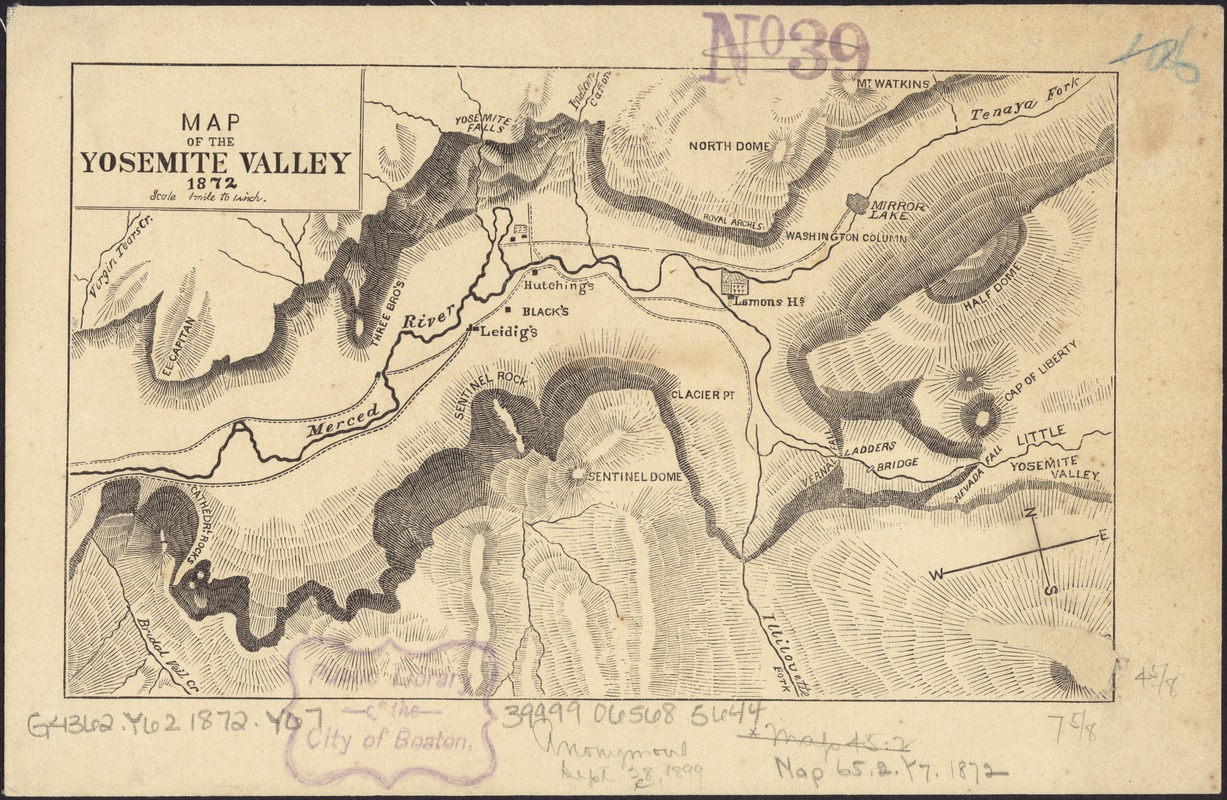
Map of the Yosemite Valley
Map of the Yosemite Valley
×
Item Information
Title:
Map of the Yosemite Valley
Date:
1872
Format:
Maps/Atlases
Location:
Boston Public Library
Norman B. Leventhal Map Center
Collection (local):
Norman B. Leventhal Map Center Collection
Subjects:
Yosemite Valley (Calif.)--Maps
Places:
California
>
Yosemite Valley
(area)
Extent:
1 map ; 12 x 20 cm.
Permalink:
https://ark.digitalcommonwealth.org/ark:/50959/4m90fc61j
Terms of Use:
No known copyright restrictions.
No known restrictions on use.
Publisher:
S.l : [s.n.]
Scale:
Scale [1:63,360]. 1 mile to 1 inch
Language:
English
Notes:
Relief shown by hachures.
Oriented with north towards the upper left.
Identifier:
06_01_011445
Call #:
G4362.Y62 1872 .Y67
Barcode:
39999065685644
show more...
View MODS XML
More Like This
Map of the Yosemite Valley : from surveys made by order of the ...
Yosemite Valley
The 100th anniversary map of Abraham Lincoln's visit to ...
1630 shoreline
Find More Like This >>
Tools
Share
Facebook
Pinterest
X
Reddit
Tumblr
Email
Copy link
Add to Folder
Questions/Comments
Cite This Item
IIIF Manifest
Downloads
Primary (full resolution, uncompressed)
(TIF, 53.3 MB)
Large (full resolution)
(JPEG, 4.48 MB)
Medium
(JPEG, 419 KB)