Skip to search
Skip to main content
Digital Commonwealth
Sign Up / Log In
Search for
Search
Search
Search
Basic
Advanced
Explore
Map
Collections
Institutions
Formats
For Educators
Primary Source Sets
Lesson Plans
Using Primary Sources
Searching Digital Commonwealth
For Institutions
Join Digital Commonwealth
Conferences, Trainings, & Events
How to Contribute Collections
Digitization Services
Board & Committees
Frequently Asked Questions
About
About Digital Commonwealth
News & Announcements
Copyright & Terms of Use
Harmful Content Statement
Partners
API
Contact Us
Boston Public Library
Norman B. Leventhal Map Center Collection
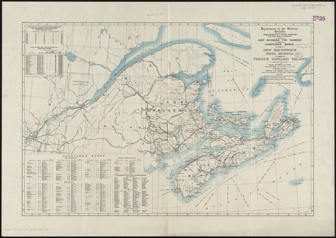
Map showing the number of chartered banks in New Brunswick, Nova Scotia, and Prince Edward Island
Map showing the number of chartered banks in New Brunswick, Nova Scotia, and Prince Edward Island
×
Item Information
Title:
Map showing the number of chartered banks in New Brunswick, Nova Scotia, and Prince Edward Island
Creator:
Canada. Department of the Interior. . Railway Lands Branch
Name on Item:
Department of the Interior, Canada ; prepared in the Railway Lands Branch under the direction of F.C.C. Lynch, superintendent.
Date:
1914
Format:
Maps/Atlases
Location:
Boston Public Library
Norman B. Leventhal Map Center
Collection (local):
Norman B. Leventhal Map Center Collection
Subjects:
Banks and banking--Maritime Provinces--Maps
Maritime Provinces--Maps
Places:
Canada
>
Province of Prince Edward Island
(province)
Extent:
1 map : col. ; 49 x 75 cm.
Permalink:
https://ark.digitalcommonwealth.org/ark:/50959/4m90ff54j
Terms of Use:
No known copyright restrictions.
No known restrictions on use.
Publisher:
[Ottawa] : Dept. of the Interior
Edition:
Prelim. ed.
Scale:
Scale [1:1,584,000]. 25 miles to 1 in.
Language:
English
Notes:
Includes 4 tables showing data on chartered banks (indexed) and government post office savings banks.
Identifier:
06_01_011589
Call #:
G3416.Q8 1914 .C36
Barcode:
39999065686022
LCCN:
gm 71003522
show more...
View MODS XML
More Like This
Map of the Eastern Railroad and principal connections
Map of the Eastern Railroad and principal connections
North America : British provinces of New Brunswick, Nova Scotia, & ...
The 100th anniversary map of Abraham Lincoln's visit to ...
Find More Like This >>
Tools
Share
Facebook
Pinterest
X
Reddit
Tumblr
Email
Copy link
Add to Folder
Questions/Comments
Cite This Item
IIIF Manifest
Downloads
Primary (full resolution, uncompressed)
(TIF, 77.1 MB)
Large (full resolution)
(JPEG, 6.48 MB)
Medium
(JPEG, 308 KB)