Skip to search
Skip to main content
Digital Commonwealth
Sign Up / Log In
Search for
Search
Search
Search
Basic
Advanced
Explore
Map
Collections
Institutions
Formats
For Educators
Primary Source Sets
Lesson Plans
Using Primary Sources
Searching Digital Commonwealth
For Institutions
Join Digital Commonwealth
Conferences, Trainings, & Events
How to Contribute Collections
Digitization Services
Board & Committees
Frequently Asked Questions
About
About Digital Commonwealth
News & Announcements
Copyright & Terms of Use
Harmful Content Statement
Partners
API
Contact Us
Boston Public Library
Norman B. Leventhal Map Center Collection
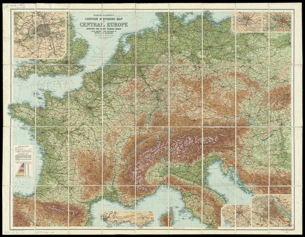
Bartholomew's contour motoring map of Central Europe showing the best touring roads with heights and distances in metres and kilometres
Bartholomews contour motoring map of Central Europe showing the best touring roads with heights and distances in metres and kilometres
×
Item Information
Title:
Bartholomew's contour motoring map of Central Europe showing the best touring roads with heights and distances in metres and kilometres
Creator:
John Bartholomew & Co
Date:
[1913?]
Format:
Maps/Atlases
Location:
Boston Public Library
Norman B. Leventhal Map Center
Collection (local):
Norman B. Leventhal Map Center Collection
Subjects:
Roads--Europe, Central--Maps
Europe, Central--Maps
Places:
Central Europe
(area)
Extent:
1 map : color ; 72 x 95 cm, folded to 21 x 12 cm
Permalink:
https://ark.digitalcommonwealth.org/ark:/50959/4m90fm67n
Terms of Use:
No known copyright restrictions.
No known restrictions on use.
Publisher:
[Edinburgh] : John Bartholomew & Co.,
Scale:
Scale 1:2,000,000
Language:
English
Notes:
Date of publication taken from date of acquisition.
Relief shown by gradient tints.
Insets: Paris -- Hamburg -- Berlin -- Vienna -- Rome -- Nice to Monaco.
Identifier:
06_01_012034
Call #:
G5701.P2 1913 .J64
Barcode:
39999065692830
show more...
View MODS XML
More Like This
The A.A.A. key road map of continental Europe
Deutschland, königr. der Niederlande, kgr. Belgien und die ...
A diagrammatic road map of Central Europe : for the use of ...
Post- und reise-karte von Deutschland und den anliegenden ländern ...
Find More Like This >>
Tools
Share
Facebook
Pinterest
X
Reddit
Tumblr
Email
Copy link
Add to Folder
Questions/Comments
Cite This Item
IIIF Manifest
Downloads
Primary (full resolution, uncompressed)
(TIF, 305 MB)
Large (full resolution)
(JPEG, 25.6 MB)
Medium
(JPEG, 434 KB)