Skip to search
Skip to main content
Digital Commonwealth
Sign Up / Log In
Search for
Search
Search
Search
Basic
Advanced
Explore
Map
Collections
Institutions
Formats
For Educators
Primary Source Sets
Lesson Plans
Using Primary Sources
Searching Digital Commonwealth
For Institutions
Join Digital Commonwealth
Conferences, Trainings, & Events
How to Contribute Collections
Digitization Services
Board & Committees
Frequently Asked Questions
About
About Digital Commonwealth
News & Announcements
Copyright & Terms of Use
Harmful Content Statement
Partners
API
Contact Us
Boston Public Library
Norman B. Leventhal Map Center Collection
/
American Revolutionary War-Era Maps (Collection of Distinction)
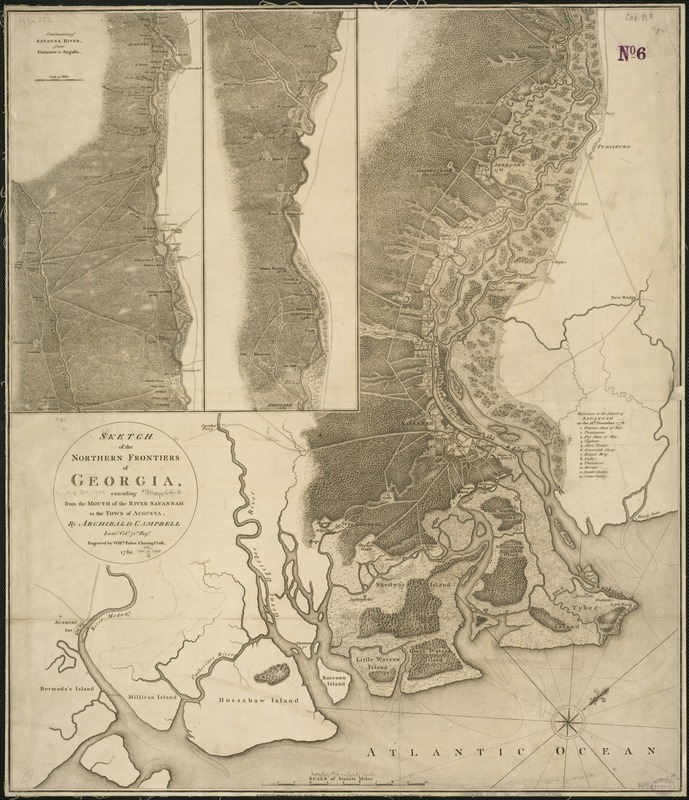
Sketch of the northern frontiers of Georgia, extending from the mouth of the River Savannah to the town of Augusta
Sketch of the northern frontiers of Georgia, extending from the mouth of the River Savannah to the town of Augusta
×
Item Information
Title:
Sketch of the northern frontiers of Georgia, extending from the mouth of the River Savannah to the town of Augusta
Creator:
Campbell, Archibald, Sir, 1739-1791
Name on Item:
by Archibald Campbell ; engraved by Willm. Faden.
Date:
1780
Format:
Maps/Atlases
Location:
Boston Public Library
Norman B. Leventhal Map Center
Collection (local):
Norman B. Leventhal Map Center Collection
Subjects:
Savannah River Valley (Ga. and S.C.)--Maps--Early works to 1800
Georgia--Boundaries--South Carolina--Maps--Early works to 1800
South Carolina--Boundaries--Georgia--Maps--Early works to 1800
Places:
South Carolina
Savannah River
Georgia
Extent:
1 map ; 69 x 60 cm.
Permalink:
https://ark.digitalcommonwealth.org/ark:/50959/6t053p626
Terms of Use:
No known copyright restrictions.
No known restrictions on use.
Publisher:
London : Wm. Faden
Scale:
Scale ca. 1:110,000.
Language:
English
Notes:
Relief shown by hachures.
Oriented with north toward the upper right.
Includes 2 insets of "Continuation of Savanna River, from Ebenezer to Augusta" and index of "References to the attack of Savannah on the 28th December 1778."
Identifier:
06_01_004083
Call #:
G3922.S3 1780 .C36
Barcode:
39999059022226
LCCN:
73694481
show more...
View MODS XML
More Like This
The 100th anniversary map of Abraham Lincoln's visit to ...
1630 shoreline
1879. Progress map of the U.S. Geographical Surveys west of the ...
1903 Map of Salem and surrounding places
Find More Like This >>
Tools
Share
Facebook
Pinterest
X
Reddit
Tumblr
Email
Copy link
Add to Folder
Questions/Comments
Cite This Item
IIIF Manifest
Downloads
Primary (full resolution, uncompressed)
(TIF, 205 MB)
Large (full resolution)
(JPEG, 17.2 MB)
Medium
(JPEG, 230 KB)