Skip to search
Skip to main content
Digital Commonwealth
Sign Up / Log In
Search for
Search
Search
Search
Basic
Advanced
Explore
Map
Collections
Institutions
Formats
For Educators
Primary Source Sets
Lesson Plans
Using Primary Sources
Searching Digital Commonwealth
For Institutions
Join Digital Commonwealth
Conferences, Trainings, & Events
How to Contribute Collections
Digitization Services
Board & Committees
Frequently Asked Questions
About
About Digital Commonwealth
News & Announcements
Copyright & Terms of Use
Harmful Content Statement
Partners
API
Contact Us
Boston Public Library
Norman B. Leventhal Map Center Collection
/
Urban Maps (Collection of Distinction)
/
American Revolutionary War-Era Maps (Collection of Distinction)
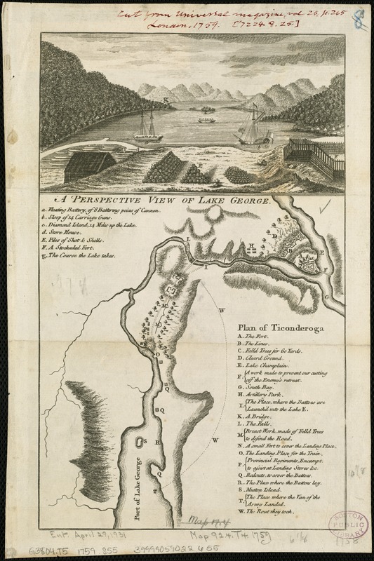
A perspective view of Lake George : Plan of Ticonderoga
A perspective view of Lake George
×
Item Information
Title:
A perspective view of Lake George : Plan of Ticonderoga
Creator:
Skinner, H.
Date:
[1759]
Format:
Maps/Atlases
Location:
Boston Public Library
Norman B. Leventhal Map Center
Collection (local):
Norman B. Leventhal Map Center Collection
Subjects:
George, Lake (N.Y. : Lake)--Aerial views--Early works to 1800
Ticonderoga (N.Y.)--History--French and Indian War, 1754-1763--Maps
Places:
George, Lake
Essex (county)
>
Ticonderoga
Extent:
1 view and 1 map on 1 sheet ; 9 x 16 cm. and 18 x 16 cm., sheet 30 x 21 cm.
Permalink:
https://ark.digitalcommonwealth.org/ark:/50959/6t053q40c
Terms of Use:
No known copyright restrictions.
No known restrictions on use.
Publisher:
London : J. Hinton
Scale:
Scale not given.
Language:
English
Notes:
Relief shown by hachures on map.
Author attribution based on Phillips.
From Universal magazine, v. 25, Nov. 1759.
Includes keys to places of interest regarding the French and Indian War.
Notes (date):
This date is inferred.
Identifier:
06_01_006313
Call #:
G3804.T5 1759 .S55
Barcode:
39999059022655
show more...
View MODS XML
More Like This
The 100th anniversary map of Abraham Lincoln's visit to ...
1630 shoreline
1879. Progress map of the U.S. Geographical Surveys west of the ...
1903 Map of Salem and surrounding places
Find More Like This >>
Tools
Share
Facebook
Pinterest
X
Reddit
Tumblr
Email
Copy link
Add to Folder
Questions/Comments
Cite This Item
IIIF Manifest
Downloads
Primary (full resolution, uncompressed)
(TIF, 40.1 MB)
Large (full resolution)
(JPEG, 3.36 MB)
Medium
(JPEG, 193 KB)