Skip to search
Skip to main content
Digital Commonwealth
Sign Up / Log In
Search for
Search
Search
Search
Basic
Advanced
Explore
Map
Collections
Institutions
Formats
For Educators
Primary Source Sets
Lesson Plans
Using Primary Sources
Searching Digital Commonwealth
For Institutions
Join Digital Commonwealth
Conferences, Trainings, & Events
How to Contribute Collections
Digitization Services
Board & Committees
Frequently Asked Questions
About
About Digital Commonwealth
News & Announcements
Copyright & Terms of Use
Harmful Content Statement
Partners
API
Contact Us
Boston Public Library
Norman B. Leventhal Map Center Collection
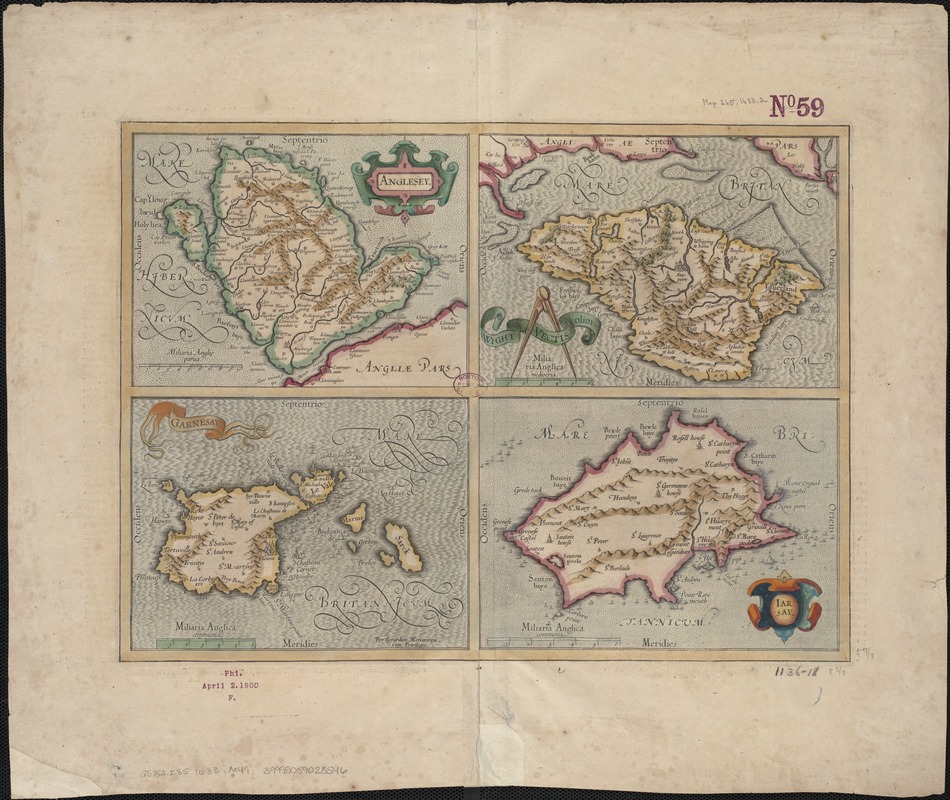
Anglesey : Wight Vectis olim ; Garnesay ; Iarsay
Anglesey
×
Item Information
Title:
Anglesey : Wight Vectis olim ; Garnesay ; Iarsay
Title (alt.):
Wight Vectis olim
Garnesay
Iarsay
Vectis
Creator:
Mercator, Gerhard, 1512-1594
Name on Item:
per Gerardum Mercatorem cum privilegio.
Date:
1633
Format:
Maps/Atlases
Location:
Boston Public Library
Norman B. Leventhal Map Center
Collection (local):
Norman B. Leventhal Map Center Collection
Subjects:
England--Maps--Early works to 1800
Isle of Wight (England)--Maps--Early works to 1800
Anglesey (Wales)--Maps--Early works to 1800
Jersey (Channel Islands)--Maps--Early works to 1800
Guernsey (Channel Islands)--Maps--Early works to 1800
Places:
England
>
Isle of Wight (county)
Wales
>
Isle of Anglesey (county)
Extent:
4 maps on 1 sheet : hand col. ; 15 x 20 cm. each, on sheet 47 x 56 cm.
Permalink:
https://ark.digitalcommonwealth.org/ark:/50959/6w924q652
Terms of Use:
No known copyright restrictions.
No known restrictions on use.
Publisher:
Amsterdam : H. Hondius
Scale:
Scales differ.
Language:
Latin
Notes:
Descriptive text in French on verso, 2O, p. 148/145.
Cut from Mercator and Hondius: Atlas ou représentation du monde universel.
Relief shown pictorially.
Identifier:
06_01_006838
Call #:
G5752.I85 1633 .M47
Barcode:
39999059028546
show more...
View MODS XML
More Like This
A map of the Isle of Wight Portsea Halinge, also the islands of ...
An accurate map of England and Wales with the principal roads from ...
Anglia Regnum
Eboracum, Lincolnia, Derbia, Staffordia, Notinghamia, Lecestria, ...
Find More Like This >>
Tools
Share
Facebook
Pinterest
X
Reddit
Tumblr
Email
Copy link
Add to Folder
Questions/Comments
Cite This Item
IIIF Manifest
Downloads
Primary (full resolution, uncompressed)
(TIF, 207 MB)
Large (full resolution)
(JPEG, 17.4 MB)
Medium
(JPEG, 283 KB)