Skip to search
Skip to main content
Digital Commonwealth
Sign Up / Log In
Search for
Search
Search
Search
Basic
Advanced
Explore
Map
Collections
Institutions
Formats
For Educators
Primary Source Sets
Lesson Plans
Using Primary Sources
Searching Digital Commonwealth
For Institutions
Join Digital Commonwealth
Conferences, Trainings, & Events
How to Contribute Collections
Digitization Services
Board & Committees
Frequently Asked Questions
About
About Digital Commonwealth
News & Announcements
Copyright & Terms of Use
Harmful Content Statement
Partners
API
Contact Us
Boston Public Library
Norman B. Leventhal Map Center Collection
A map of the island of Corsica
A map of the island of Corsica
×
Item Information
Title:
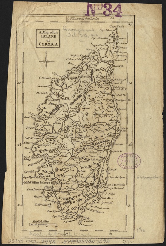
A map of the island of Corsica
Creator:
Jefferys, Thomas, d. 1771
Date:
[1757]
Format:
Maps/Atlases
Location:
Boston Public Library
Norman B. Leventhal Map Center
Collection (local):
Norman B. Leventhal Map Center Collection
Subjects:
Corsica (France)--Maps--Early works to 1800
Places:
France
>
Corsica
(region)
>
Corsica
(island)
France
>
Corsica
(region)
Extent:
1 map ; 18 x 9 cm.
Permalink:
https://ark.digitalcommonwealth.org/ark:/50959/794083254
Terms of Use:
No known copyright restrictions.
No known restrictions on use.
Publisher:
London : s.n.
Scale:
Scale ca. 1:1,039,000.
Language:
English
Notes:
Appears in Gentlemen's Magazine. Vol. 27, Oct. 1757, opp. p. 448.
Relief shown pictorially.
Notes (date):
This date is inferred.
Identifier:
06_01_006610
Call #:
G5970 1757 .J44x
Barcode:
39999059027092
show more...
View MODS XML
More Like This
Descriptio Corsicae insulae : Descriptio Sardiniae insulae
Insularum Sardiniae et Corsicae
Tabula moderna Italie
The 100th anniversary map of Abraham Lincoln's visit to ...
Find More Like This >>
Tools
Share
Facebook
Pinterest
X
Reddit
Tumblr
Email
Copy link
Add to Folder
Questions/Comments
Cite This Item
IIIF Manifest
Downloads
Primary (full resolution, uncompressed)
(TIF, 48.8 MB)
Large (full resolution)
(JPEG, 4.09 MB)
Medium
(JPEG, 203 KB)